File:Tottori pref.png
Tottori_pref.png (248 × 104 pixels, file size: 5 KB, MIME type: image/png)
Captions
Captions
Summary
[edit]
| Description |
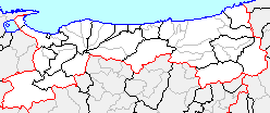
日本語: 鳥取県、市町村境界図 |
||
| Source | File:Japan map.png | ||
| Author |
|
||
| Permission (Reusing this file) |
|
Licensing
[edit]

|
Permission is granted to copy, distribute and/or modify this document under the terms of the GNU Free Documentation License, Version 1.2 or any later version published by the Free Software Foundation; with no Invariant Sections, no Front-Cover Texts, and no Back-Cover Texts. A copy of the license is included in the section entitled GNU Free Documentation License. |
- You are free:
- to share – to copy, distribute and transmit the work
- to remix – to adapt the work
- Under the following conditions:
- attribution – You must give appropriate credit, provide a link to the license, and indicate if changes were made. You may do so in any reasonable manner, but not in any way that suggests the licensor endorses you or your use.
- share alike – If you remix, transform, or build upon the material, you must distribute your contributions under the same or compatible license as the original.
File history
Click on a date/time to view the file as it appeared at that time.
| Date/Time | Thumbnail | Dimensions | User | Comment | |
|---|---|---|---|---|---|
| current | 03:11, 17 April 2005 | | 248 × 104 (5 KB) | 吉田勝男 (talk | contribs) | 初版以降の合併境界線をグレイで加筆(2005年3月31日付) |
| 16:22, 31 December 2004 |  | 248 × 104 (4 KB) | Wikiwikicompany (talk | contribs) | 鳥取県、伯耆町成立を反映(2005年1月1日付)、初版以降の合併境界線をグレイで加筆 | |
| 07:42, 3 November 2004 |  | 248 × 104 (4 KB) | Zlan (talk | contribs) | 鳥取県、鳥取市成立を反映(2004年11月1日付)、初版以降の合併境界線をグレイで加筆 | |
| 08:47, 10 October 2004 |  | 248 × 104 (3 KB) | 赤鉛筆 (talk | contribs) | 鳥取県、東伯郡湯梨浜町成立を反映(2004年10月1日付)、初版以降の合併境界線をグレイで加筆 | |
| 08:29, 10 October 2004 |  | 248 × 104 (3 KB) | 赤鉛筆 (talk | contribs) | 鳥取県、西伯郡南部町成立を反映(2004年10月1日付) | |
| 14:58, 31 August 2004 |  | 248 × 104 (3 KB) | Ultratomio (talk | contribs) | 東伯郡琴浦町成立を反映 | |
| 15:47, 14 February 2004 |  | 248 × 104 (2 KB) | Koba-chan (talk | contribs) | 鳥取県、市町村境界図 |
You cannot overwrite this file.
File usage on Commons
There are no pages that use this file.