File:Topp B's primær- og sekundærfaktor.svg
Jump to navigation
Jump to search

Size of this PNG preview of this SVG file: 800 × 411 pixels. Other resolutions: 320 × 164 pixels | 640 × 329 pixels | 1,024 × 526 pixels | 1,280 × 658 pixels | 2,560 × 1,316 pixels | 1,070 × 550 pixels.
Original file (SVG file, nominally 1,070 × 550 pixels, file size: 6 KB)
Captions
Captions
Add a one-line explanation of what this file represents
Summary
[edit]
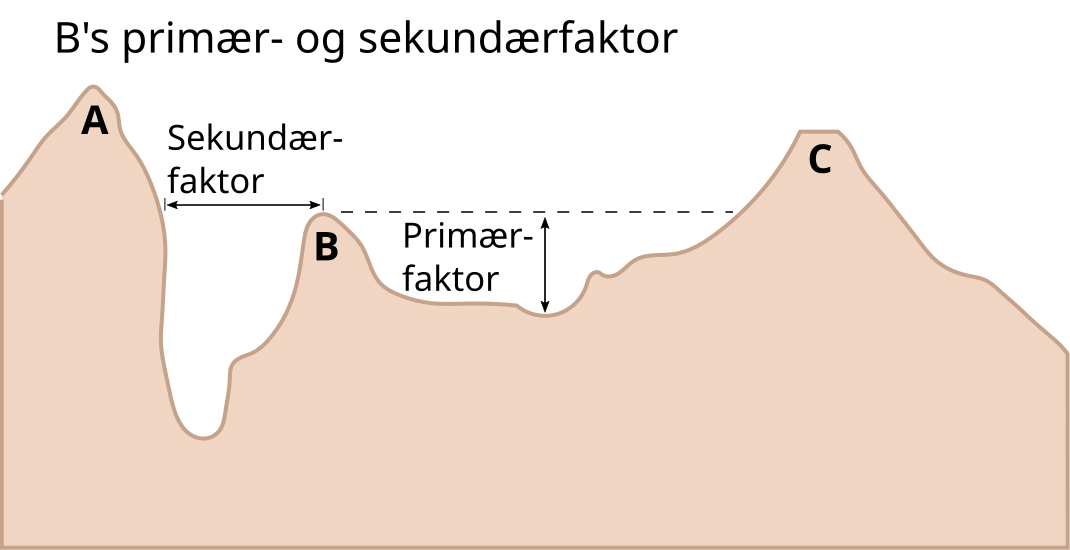
| Description | Diagram illustrating topographic prominence and isolation (font size and mountain colour changed). |
| Date | 28 June 2023 |
| Source | Created by mixing File:Topographic isolation and prominence.svg and File:Topp B's primær- og sekundærfaktor.png |
| Author | Utfor |
| Other versions | File:Topographic isolation and prominence.svg and File:Topp B's primær- og sekundærfaktor.png |
Licensing
[edit]
This file is licensed under the Creative Commons Attribution-Share Alike 3.0 Unported license.
- You are free:
- to share – to copy, distribute and transmit the work
- to remix – to adapt the work
- Under the following conditions:
- attribution – You must give appropriate credit, provide a link to the license, and indicate if changes were made. You may do so in any reasonable manner, but not in any way that suggests the licensor endorses you or your use.
- share alike – If you remix, transform, or build upon the material, you must distribute your contributions under the same or compatible license as the original.
File history
Click on a date/time to view the file as it appeared at that time.
| Date/Time | Thumbnail | Dimensions | User | Comment | |
|---|---|---|---|---|---|
| current | 20:01, 28 June 2023 | | 1,070 × 550 (6 KB) | Utfor (talk | contribs) | {{Information |Description=Diagram illustrating w:topographic prominence and isolation (font size and mountain colour changed). |Source=Created by mixing File:Topographic isolation and prominence.svg and File:Topp B's primær- og sekundærfaktor.png |Date=28 June 2023 |Author= |Permission= |other_versions=File:Topographic isolation and prominence.svg and File:Topp B's primær- og sekundærfaktor.png }} Category:Topography diagrams |
You cannot overwrite this file.
File usage on Commons
There are no pages that use this file.
File usage on other wikis
The following other wikis use this file:
- Usage on no.wikipedia.org