File:Topography Between Mars Helicopter and Rover for Flight 17 (PIA24980).png
Jump to navigation
Jump to search

Size of this preview: 800 × 203 pixels. Other resolutions: 320 × 81 pixels | 1,024 × 260 pixels.
Original file (1,024 × 260 pixels, file size: 7 KB, MIME type: image/png)
Captions
Captions
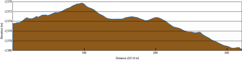
This image from provides a look at the elevation profile between the Perseverance Mars rover and Ingenuity helicopter after the rotorcraft’s 17th flight at Mars on December 5, 2021
Summary
[edit]| Description |
English: This image from provides a look at the altitude of surface features standing between the Perseverance Mars rover and Ingenuity helicopter after the rotorcraft’s 17th flight at Mars on December 5, 2021.
Image Credit: NASA/JPL-Caltech/ASU |
| Date | |
| Source | https://photojournal.jpl.nasa.gov/catalog/ |
| Author | NASA/JPL-Caltech |
| Other versions |
.png)
.png&action=edit§ion=1)
Licensing
[edit].png&action=edit§ion=2)
| This file is in the public domain in the United States because it was solely created by NASA. NASA copyright policy states that "NASA material is not protected by copyright unless noted". (See Template:PD-USGov, NASA copyright policy page or JPL Image Use Policy.) | ||
 |
Warnings:
|
This image or video was catalogued by Jet Propulsion Laboratory of the United States National Aeronautics and Space Administration (NASA) under Photo ID: PIA24980. This tag does not indicate the copyright status of the attached work. A normal copyright tag is still required. See Commons:Licensing. Other languages:
|
File history
Click on a date/time to view the file as it appeared at that time.
| Date/Time | Thumbnail | Dimensions | User | Comment | |
|---|---|---|---|---|---|
| current | 06:19, 8 December 2021 | 1,024 × 260 (7 KB) | Cherurbino (talk | contribs) | Uploaded a work by NASA/JPL-Caltech from https://photojournal.jpl.nasa.gov/catalog/ with UploadWizard |
You cannot overwrite this file.
File usage on Commons
The following page uses this file:
File usage on other wikis
The following other wikis use this file:
- Usage on ru.wikipedia.org
.png&oldid=718212975)