File:Topographic map of the Ciskei.svg
Jump to navigation
Jump to search

Size of this PNG preview of this SVG file: 484 × 599 pixels. Other resolutions: 194 × 240 pixels | 388 × 480 pixels | 620 × 768 pixels | 827 × 1,024 pixels | 1,654 × 2,048 pixels | 492 × 609 pixels.
Original file (SVG file, nominally 492 × 609 pixels, file size: 807 KB)
Captions
Captions
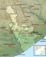
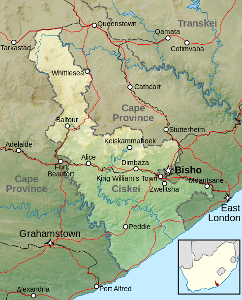
Topographic map of the Ciskei region, current Eastern Cape, South Africa, reflecting the period 1981 to 1994.
Summary
[edit]
| Description |
Afrikaans: Topografiese kaart van die voormalige Ciskei-tuisland wat vanaf 1981 tot 1994 nominaal onafhanklik van Suid-Afrika was. Aangedui is die terrein, groter riviere, hoofpaaie, spoorweë en hoofsentra.
English: Topographic map of the Ciskei, a former bantustan that was nominally independent of South Africa from 1981 to 1994. Included are terrain, major rivers, main roads, railways and main towns. |
|||
| Date | ||||
| Source |
|
|||
| Author | Htonl | |||
| Permission (Reusing this file) |
This file is licensed under the Creative Commons Attribution-Share Alike 3.0 Unported license.
|
File history
Click on a date/time to view the file as it appeared at that time.
| Date/Time | Thumbnail | Dimensions | User | Comment | |
|---|---|---|---|---|---|
| current | 22:04, 5 April 2013 | | 492 × 609 (807 KB) | Htonl (talk | contribs) | labels |
| 11:36, 5 April 2013 |  | 492 × 609 (824 KB) | Htonl (talk | contribs) | {{Information |Description ={{en|1=Topographic map of the w:Ciskei, a former bantustan that was nominally independent of South Africa. Includes terrain, major rivers, main roads, railways and main towns.}} |So... |
You cannot overwrite this file.
File usage on Commons
There are no pages that use this file.
File usage on other wikis
The following other wikis use this file:
- Usage on af.wikipedia.org
- Usage on de.wikipedia.org
- Usage on en.wikipedia.org
- Usage on es.wikipedia.org
- Usage on frr.wikipedia.org
- Usage on he.wikipedia.org
- Usage on nl.wikipedia.org
- Usage on pl.wikipedia.org
- Usage on zh.wikipedia.org