File:Topographic map of Socotra-en.svg
Jump to navigation
Jump to search

Size of this PNG preview of this SVG file: 800 × 229 pixels. Other resolutions: 320 × 92 pixels | 640 × 183 pixels | 1,024 × 293 pixels | 1,280 × 367 pixels | 2,560 × 733 pixels | 1,309 × 375 pixels.
Original file (SVG file, nominally 1,309 × 375 pixels, file size: 572 KB)
Captions
Captions
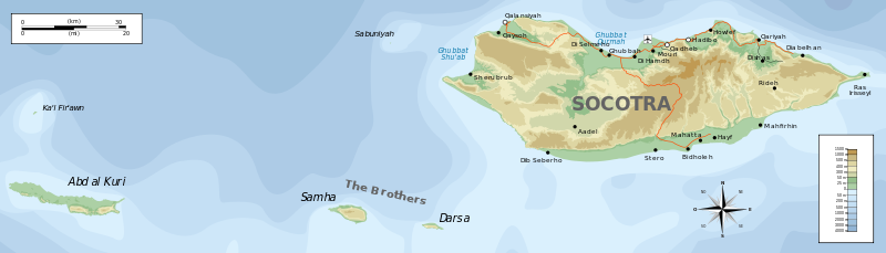
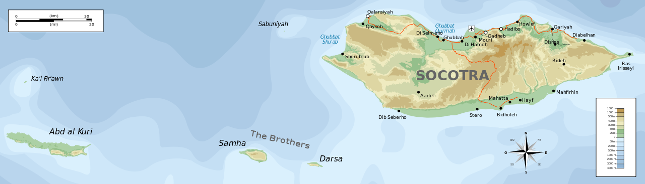
Topographic map of the Socotra archipelago
Summary
[edit]
| Description |
English: Topographic map of Socotra.
Deutsch: Topographische Karte von Sokotra.
Français : Carte topographique de Socotra.
Македонски: Топографска карта на Сокотра.
Suomi: Sokotran topografinen kartta.
Русский: Топографическая карта Сокотры |
| Date | |
| Source |
Self-made in Inkscape. |
| Author | Oona Räisänen (Mysid) |
| Other versions |
Derivative works of this file: |

|
This SVG file contains embedded text that can be translated into your language, using any capable SVG editor, text editor or the SVG Translate tool. For more information see: About translating SVG files. |
Licensing
[edit]
I, the copyright holder of this work, hereby publish it under the following licenses:

|
Permission is granted to copy, distribute and/or modify this document under the terms of the GNU Free Documentation License, Version 1.2 or any later version published by the Free Software Foundation; with no Invariant Sections, no Front-Cover Texts, and no Back-Cover Texts. A copy of the license is included in the section entitled GNU Free Documentation License. |
This file is licensed under the Creative Commons Attribution-Share Alike Attribution-Share Alike 4.0 International, 3.0 Unported, 2.5 Generic, 2.0 Generic and 1.0 Generic license.
- You are free:
- to share – to copy, distribute and transmit the work
- to remix – to adapt the work
- Under the following conditions:
- attribution – You must give appropriate credit, provide a link to the license, and indicate if changes were made. You may do so in any reasonable manner, but not in any way that suggests the licensor endorses you or your use.
- share alike – If you remix, transform, or build upon the material, you must distribute your contributions under the same or compatible license as the original.
You may select the license of your choice.
File history
Click on a date/time to view the file as it appeared at that time.
| Date/Time | Thumbnail | Dimensions | User | Comment | |
|---|---|---|---|---|---|
| current | 19:08, 29 June 2010 | 1,309 × 375 (572 KB) | Mysid (talk | contribs) | removing buggy shading | |
| 19:05, 29 June 2010 | 1,309 × 375 (1.13 MB) | Mysid (talk | contribs) | update | ||
| 22:24, 19 May 2008 | 1,309 × 375 (229 KB) | Mysid (talk | contribs) | bugfix #1 | ||
| 22:23, 19 May 2008 | 1,309 × 375 (229 KB) | Mysid (talk | contribs) | == {{int:filedesc}} == {{Information |Description= {{en|Topographic map of en:Socotra.}} {{fr|Carte topographique du fr:Socotra.}} {{fi|fi:Sokotran topografinen kartta.}} |Source=Self-made in Inkscape.<br/>Boundaries, roads, and place na |
You cannot overwrite this file.
File usage on Commons
The following 4 pages use this file:
.svg)
File usage on other wikis
The following other wikis use this file:
- Usage on af.wikipedia.org
- Usage on ar.wikipedia.org
- Usage on az.wikipedia.org
- Usage on bg.wikipedia.org
- Usage on bn.wikipedia.org
- Usage on bs.wikipedia.org
- Usage on ca.wikipedia.org
- Usage on ckb.wikipedia.org
- Usage on cs.wikipedia.org
- Usage on cy.wikipedia.org
- Usage on da.wikipedia.org
- Usage on de.wikipedia.org
- Usage on en.wikipedia.org
- Usage on et.wikipedia.org
- Usage on fr.wikipedia.org
- Usage on gl.wikipedia.org
- Usage on he.wikipedia.org
- Usage on hr.wikipedia.org
- Usage on hu.wikipedia.org
- Usage on is.wikipedia.org
- Usage on it.wikipedia.org
- Usage on ja.wikipedia.org
- Usage on ka.wikipedia.org
- Usage on lt.wikipedia.org
- Usage on ms.wikipedia.org
- Usage on nl.wikipedia.org
- Usage on nn.wikipedia.org
View more global usage of this file.