File:Tooelecounty.png
Jump to navigation
Jump to search

Size of this preview: 742 × 599 pixels. Other resolutions: 297 × 240 pixels | 594 × 480 pixels | 951 × 768 pixels | 1,024 × 827 pixels.
Original file (1,024 × 827 pixels, file size: 149 KB, MIME type: image/png)
Captions
Captions
Add a one-line explanation of what this file represents
Summary
[edit]
| Description |
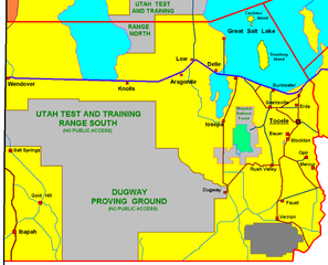
Tooele County , selfmade graphic by R.Blauert Dk4hb |
| Date | 29 January 2006 (original upload date) |
| Source | No machine-readable source provided. Own work assumed (based on copyright claims). |
| Author | No machine-readable author provided. Dk4hb~commonswiki assumed (based on copyright claims). |
Licensing
[edit]
| This work has been released into the public domain by its author, I, Dk4hb. This applies worldwide. In some countries this may not be legally possible; if so: I, Dk4hb grants anyone the right to use this work for any purpose, without any conditions, unless such conditions are required by law. |
File history
Click on a date/time to view the file as it appeared at that time.
| Date/Time | Thumbnail | Dimensions | User | Comment | |
|---|---|---|---|---|---|
| current | 19:40, 29 January 2006 | | 1,024 × 827 (149 KB) | Dk4hb~commonswiki (talk | contribs) | Tooele County , selfmade graphic by R.Blauert(dk4hb) |
You cannot overwrite this file.
File usage on Commons
There are no pages that use this file.
File usage on other wikis
The following other wikis use this file:
- Usage on de.wikipedia.org
- Usage on ja.wikipedia.org
- Usage on la.wikipedia.org
Categories:
- Maps of Tooele County, Utah
- Great Salt Lake Desert
- Dugway Proving Ground
- Utah Test and Training Range
- Maps of the Great Salt Lake
- Maps of Dugway, Utah
- Salt Springs, Utah
- Ibapah, Utah
- Gold Hill, Utah
- Wendover, Utah
- Knolls, Utah
- Argonite, Utah
- Low, Utah
- Delle, Utah
- Faust, Utah
- Vernon, Utah
- Buildings in Tooele, Utah
- Bauer, Utah
- Stockton, Utah
- Maps of Ophir, Utah
- Maps of Mercur, Utah
- Erda, Utah
- Grantsville, Utah
- Burmester, Utah
- Iosepa, Utah
- Rush Valley, Utah
- Stansbury Island
- Carrinton Island