File:Tohoku Shinkansen map.png
Jump to navigation
Jump to search

Size of this preview: 339 × 599 pixels. Other resolutions: 136 × 240 pixels | 272 × 480 pixels | 940 × 1,660 pixels.
Original file (940 × 1,660 pixels, file size: 58 KB, MIME type: image/png)
Captions
Captions
Add a one-line explanation of what this file represents

|
This transport map image could be re-created using vector graphics as an SVG file. This has several advantages; see Commons:Media for cleanup for more information. If an SVG form of this image is available, please upload it and afterwards replace this template with
{{vector version available|new image name}}.
It is recommended to name the SVG file “Tohoku Shinkansen map.svg”—then the template Vector version available (or Vva) does not need the new image name parameter. |
Summary
[edit]
| Description |
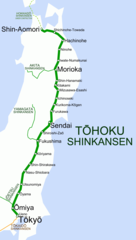
English: Map of Tōhoku Shinkansen. |
| Date | |
| Source | Own work |
| Author | Hisagi (氷鷺) |
| Other versions | 日本語: File:Tohoku Shinkansen map ja.png |
Licensing
[edit]
I, the copyright holder of this work, hereby publish it under the following licenses:
This file is licensed under the Creative Commons Attribution-Share Alike 3.0 Unported license.
- You are free:
- to share – to copy, distribute and transmit the work
- to remix – to adapt the work
- Under the following conditions:
- attribution – You must give appropriate credit, provide a link to the license, and indicate if changes were made. You may do so in any reasonable manner, but not in any way that suggests the licensor endorses you or your use.
- share alike – If you remix, transform, or build upon the material, you must distribute your contributions under the same or compatible license as the original.

|
Permission is granted to copy, distribute and/or modify this document under the terms of the GNU Free Documentation License, Version 1.2 or any later version published by the Free Software Foundation; with no Invariant Sections, no Front-Cover Texts, and no Back-Cover Texts. A copy of the license is included in the section entitled GNU Free Documentation License. |
You may select the license of your choice.
File history
Click on a date/time to view the file as it appeared at that time.
| Date/Time | Thumbnail | Dimensions | User | Comment | |
|---|---|---|---|---|---|
| current | 13:59, 23 July 2012 | | 940 × 1,660 (58 KB) | Hisagi (talk | contribs) | Reverted to version as of 15:03, 3 December 2010 |
| 14:54, 11 December 2011 |  | 940 × 1,660 (64 KB) | DAJF (talk | contribs) | removed distracting (and in some cases incorrect) macron usage | |
| 15:03, 3 December 2010 |  | 940 × 1,660 (58 KB) | Hisagi (talk | contribs) | 12/4開業分を更新 | |
| 08:36, 7 September 2010 |  | 960 × 1,690 (53 KB) | Hisagi (talk | contribs) | {{Information |Description={{en|1=Map of Tōhoku Shinkansen. Broken green line (Hachinohe~Shin-Aomori) is under construction. It will be opened on 4 December 2010.}} |Source={{own}} |Author=Hisagi |Date=2010-09-07 |
You cannot overwrite this file.
File usage on Commons
The following 4 pages use this file:
File usage on other wikis
The following other wikis use this file:
- Usage on ar.wikipedia.org
- Usage on cs.wikipedia.org
- Usage on de.wikipedia.org
- Usage on en.wikipedia.org
- Usage on es.wikipedia.org
- Usage on fa.wikipedia.org
- Usage on fr.wikipedia.org
- Usage on hu.wikipedia.org
- Usage on id.wikipedia.org
- Usage on ja.wikipedia.org
- Usage on jv.wikipedia.org
- Usage on mr.wikipedia.org
- Usage on nl.wikipedia.org
- Usage on pl.wikipedia.org
- Usage on pt.wikipedia.org
- Usage on ru.wikipedia.org
- Usage on sv.wikipedia.org
- Usage on th.wikipedia.org
- Usage on tr.wikipedia.org
- Usage on uk.wikipedia.org
- Usage on vi.wikipedia.org
- Usage on www.wikidata.org