File:Tissot indicatrix world map Mercator proj.svg
Jump to navigation
Jump to search

Size of this PNG preview of this SVG file: 603 × 600 pixels. Other resolutions: 241 × 240 pixels | 483 × 480 pixels | 772 × 768 pixels | 1,029 × 1,024 pixels | 2,059 × 2,048 pixels | 3,000 × 2,984 pixels.
Original file (SVG file, nominally 3,000 × 2,984 pixels, file size: 550 KB)
Captions
Captions
Add a one-line explanation of what this file represents
Summary
[edit]
| Description |
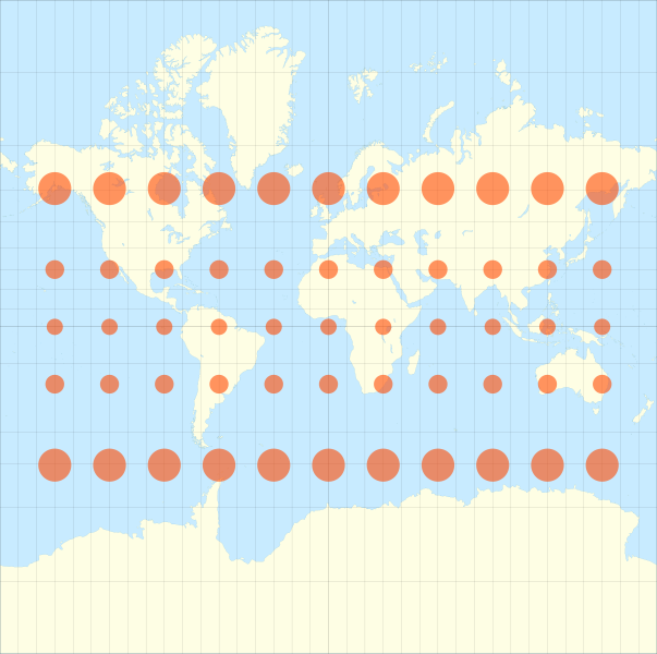
English: Map of the world in a Mercator projection (cropped at 85° of latitude) with Tissot's Indicatrix of deformation.
Each red circle/ellipse has a radius of 500 km. Scale : 1:5,000,000 Français : Carte du monde suivant une projection de Mercator (arrêtée à 85° de latitude) avec indicatrices de déformation de Tissot.
WGS84 datum, central meridian : 0°, origin latitude : 0°.Chaque cercle/ellipse rouge a un rayon de 500 km. Échelle : 1:5 000 000. |
||
| Date | |||
| Source |
Own work
|
||
| Author | Eric Gaba (Sting - fr:Sting) | ||
| Permission (Reusing this file) |
|
Licensing
[edit]
I, the copyright holder of this work, hereby publish it under the following licenses:

|
Permission is granted to copy, distribute and/or modify this document under the terms of the GNU Free Documentation License, Version 1.2 or any later version published by the Free Software Foundation; with no Invariant Sections, no Front-Cover Texts, and no Back-Cover Texts. A copy of the license is included in the section entitled GNU Free Documentation License. |
This file is licensed under the Creative Commons Attribution-Share Alike 4.0 International, 3.0 Unported, 2.5 Generic, 2.0 Generic and 1.0 Generic license.
- You are free:
- to share – to copy, distribute and transmit the work
- to remix – to adapt the work
- Under the following conditions:
- attribution – You must give appropriate credit, provide a link to the license, and indicate if changes were made. You may do so in any reasonable manner, but not in any way that suggests the licensor endorses you or your use.
- share alike – If you remix, transform, or build upon the material, you must distribute your contributions under the same or compatible license as the original.
You may select the license of your choice.
File history
Click on a date/time to view the file as it appeared at that time.
| Date/Time | Thumbnail | Dimensions | User | Comment | |
|---|---|---|---|---|---|
| current | 20:51, 10 August 2013 | | 3,000 × 2,984 (550 KB) | Sidpatil (talk | contribs) | Filesize reduced with `scour`. |
| 20:39, 1 September 2008 |  | 3,000 × 2,984 (1.45 MB) | Sting (talk | contribs) | == Summary == {{Information |Description={{en|Map of the world in a Mercator projection (cropped at 85° of latitude) with Tissot's Indicatrix of deformation.<br/>Each red circle/ellipse has a radius |
You cannot overwrite this file.
File usage on Commons
The following page uses this file:
File usage on other wikis
The following other wikis use this file:
- Usage on ar.wikipedia.org
- Usage on ca.wikipedia.org
- Usage on en.wikipedia.org
- Usage on en.wikibooks.org
- Usage on es.wikipedia.org
- Usage on fr.wikipedia.org
- Usage on fr.wikiversity.org
- Usage on it.wikipedia.org
- Usage on ms.wikipedia.org
- Usage on sr.wikipedia.org
- Usage on sv.wikipedia.org
- Usage on ta.wikipedia.org
- Usage on tr.wikipedia.org