File:Tischlerspitze above Anlauftal from Hannoverhaus (S).jpg

Original file (8,647 × 2,412 pixels, file size: 13.59 MB, MIME type: image/jpeg)
Captions
Captions
Summary
[edit].jpg&action=edit§ion=1)
| Description |
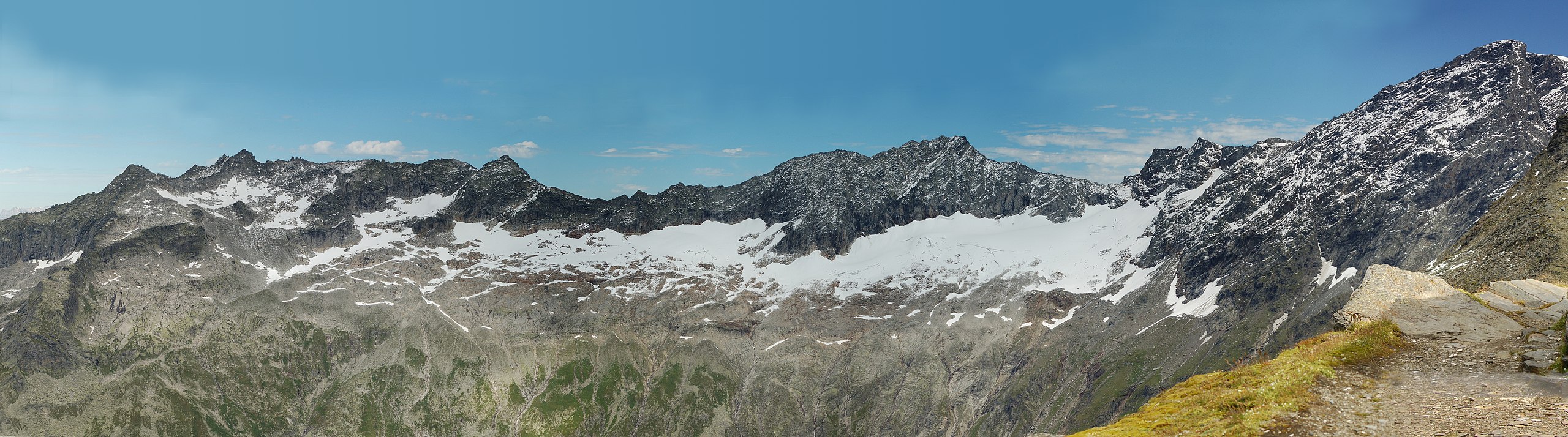
English: Panorama from Hannoverhaus, Ankogel Group. View to north to Hölltorkamm, into Salzburg.
f.l.t.r.: Hölltorspitz (2847m), Hölltorkogel (2905m), Grubenkarwand, Tischlerspitze (3002m), Untere Grubenkarscharte (2848m), Schwarzkopf (3271m). In front the glacier Grubenkarkees.Deutsch: Panorama vom Hannoverhaus, Ankogelgruppe. Blick nach Norden auf den Hölltorkamm ins Salzburgische.
v.l.n.r.: Hölltorspitz (2847m), Hölltorkogel (2905m), Grubenkarwand, Tischlerspitze (3002m), Untere Grubenkarscharte (2848m), Schwarzkopf (3271m). Davor das Grubenkarkees. |
| Date | |
| Source | Own work |
| Author | Herzi Pinki |
| Camera location | | View this and other nearby images on: OpenStreetMap |
|---|
.jpg¶ms=047.043889_N_0013.214444_E_globe:Earth_type:camera_heading:0.00&language=en)
Licensing
[edit].jpg&action=edit§ion=2)
- You are free:
- to share – to copy, distribute and transmit the work
- to remix – to adapt the work
- Under the following conditions:
- attribution – You must give appropriate credit, provide a link to the license, and indicate if changes were made. You may do so in any reasonable manner, but not in any way that suggests the licensor endorses you or your use.
- share alike – If you remix, transform, or build upon the material, you must distribute your contributions under the same or compatible license as the original.

|
Permission is granted to copy, distribute and/or modify this document under the terms of the GNU Free Documentation License, Version 1.2 or any later version published by the Free Software Foundation; with no Invariant Sections, no Front-Cover Texts, and no Back-Cover Texts. A copy of the license is included in the section entitled GNU Free Documentation License. |
| Annotations | This image is annotated: View the annotations at Commons |
.jpg)
File history
Click on a date/time to view the file as it appeared at that time.
| Date/Time | Thumbnail | Dimensions | User | Comment | |
|---|---|---|---|---|---|
| current | 16:49, 6 January 2009 | 8,647 × 2,412 (13.59 MB) | Herzi Pinki (talk | contribs) | {{Information |Description={{en|1=Panorama from Hannoverhaus, Ankogel Group. View to north to Hölltorkamm, into Salzburg. f.l.t.r.: Hölltorspitz (2847m), Hölltorkogel (2905m), Grubenkarwand, Tischlerspitze (3002m), Untere Grubenkarscharte (2848m), Schw |
You cannot overwrite this file.
File usage on Commons
There are no pages that use this file.
File usage on other wikis
The following other wikis use this file:
- Usage on ceb.wikipedia.org
- Usage on de.wikipedia.org
- Usage on www.wikidata.org
- Usage on zh.wikipedia.org
Metadata
This file contains additional information such as Exif metadata which may have been added by the digital camera, scanner, or software program used to create or digitize it. If the file has been modified from its original state, some details such as the timestamp may not fully reflect those of the original file. The timestamp is only as accurate as the clock in the camera, and it may be completely wrong.
| City shown | Hannover Hütte | ||||
|---|---|---|---|---|---|
| Short title | Hannoverhaus nach N | ||||
| Image title | (v.l.n.r.)
Hölltorspitz (2847m),
Hölltorkogel (2905m),
Grubenkarwand,
Tischlerspitze (3002m),
Untere Grubenkarscharte (2848m),
Schwarzkopf (3271m),
Davor das Grubenkarkees.
| ||||
| IIM version | 2 | ||||
| Province or state shown | Kärnten | ||||
| Keywords |
|
.jpg&oldid=643786018)