File:Tidenems.png
Jump to navigation
Jump to search

Size of this preview: 600 × 600 pixels. Other resolutions: 240 × 240 pixels | 480 × 480 pixels | 768 × 768 pixels | 1,024 × 1,024 pixels | 2,085 × 2,085 pixels.
Original file (2,085 × 2,085 pixels, file size: 2.03 MB, MIME type: image/png)
Captions
Captions
Add a one-line explanation of what this file represents
Summary
[edit]
| Description |
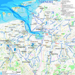
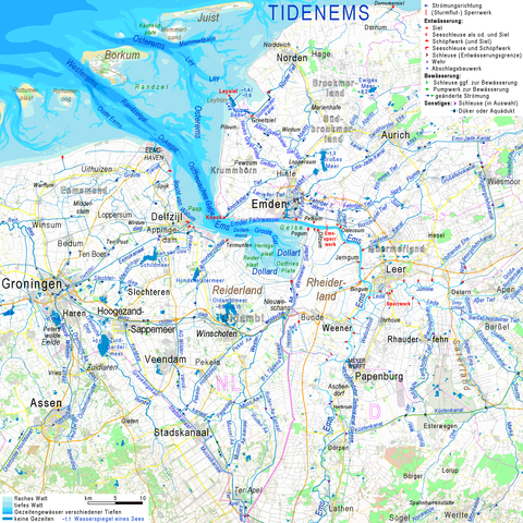
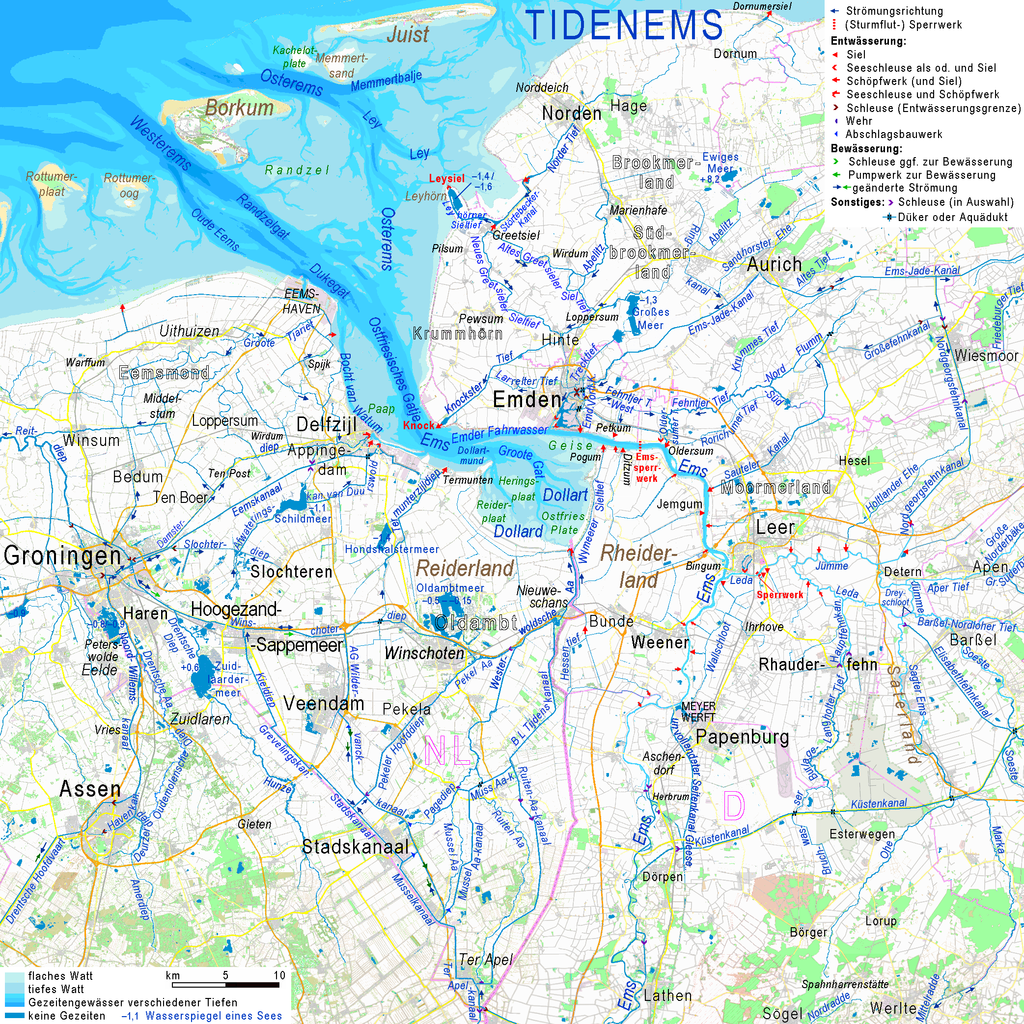
Deutsch: Tidenbereich der Ems, bestenhend aus den einander überlappenden Bereichen der Unterems (vom Wehr bei Hebrum bis zur Linie Delfzijl–Pilsum) und der Außenems (von der inneren Emsmündung bei Pogum bis zum Auslaufen der Strömungsrinnen westlich von Borkum). Unterschieden sind flaches Watt und tiefes Watt, sowie vier unterschiedliche Wassertiefen unterhalb des Seekarten-Null. Farblich davon abgehoben sind vor den Gezeiten abgeschirmte Gewässer. Vom Niveau ihrer Wasserspiegel und ihrer Gewässersohlen her wären ohne Siele nahezu alle Gewässer im dargestellten Gebiet tidenabhängig. English: Estuary of river Ems; two levels of mudflats and four ground levels of tidal waterbodies distingushed by colour, different colour for waterbodies separated from tidal influence. Wihtout artificial shelter, almost all waterbodies in the region shown in this map would be liable to the tides. |
|||||||||||||||
| Date | ||||||||||||||||
| Source |
|
|||||||||||||||
| Author | Ulamm (talk) | |||||||||||||||
| Other versions |
|
Licensing
[edit]
I, the copyright holder of this work, hereby publish it under the following licenses:

|
Permission is granted to copy, distribute and/or modify this document under the terms of the GNU Free Documentation License, Version 1.2 or any later version published by the Free Software Foundation; with no Invariant Sections, no Front-Cover Texts, and no Back-Cover Texts. A copy of the license is included in the section entitled GNU Free Documentation License. |
This file is licensed under the Creative Commons Attribution-Share Alike Attribution-Share Alike 4.0 International, 3.0 Unported, 2.5 Generic, 2.0 Generic and 1.0 Generic license.
- You are free:
- to share – to copy, distribute and transmit the work
- to remix – to adapt the work
- Under the following conditions:
- attribution – You must give appropriate credit, provide a link to the license, and indicate if changes were made. You may do so in any reasonable manner, but not in any way that suggests the licensor endorses you or your use.
- share alike – If you remix, transform, or build upon the material, you must distribute your contributions under the same or compatible license as the original.
You may select the license of your choice.
File history
Click on a date/time to view the file as it appeared at that time.
| Date/Time | Thumbnail | Dimensions | User | Comment | |
|---|---|---|---|---|---|
| current | 14:16, 12 January 2019 | | 2,085 × 2,085 (2.03 MB) | Ulamm (talk | contribs) | name: Termunten; grammar of the key |
| 07:33, 11 April 2017 |  | 2,085 × 2,085 (2.03 MB) | Ulamm (talk | contribs) | level of Ley reserve basin | |
| 20:37, 17 March 2017 |  | 2,085 × 2,085 (2.03 MB) | Ulamm (talk | contribs) | two more names | |
| 20:21, 17 March 2017 |  | 2,085 × 2,085 (2.03 MB) | Ulamm (talk | contribs) | Ledasperrwerk | |
| 20:53, 16 March 2017 |  | 2,085 × 2,085 (2.03 MB) | Ulamm (talk | contribs) | + Hauptfehnkanal + Hondshalstermeer | |
| 13:42, 13 March 2017 |  | 2,085 × 2,085 (2.02 MB) | Ulamm (talk | contribs) | some details | |
| 12:03, 13 March 2017 |  | 2,085 × 2,085 (2.02 MB) | Ulamm (talk | contribs) | completed | |
| 01:07, 13 March 2017 |  | 2,085 × 2,085 (2.03 MB) | Ulamm (talk | contribs) | {{Information |Description= {{de|Tidenbereich der Ems, bestenhend aus den einander überlappenden Bereichen der Unterems (vom Wehr bei Hebrum bis zur Linie Delfzijl–Pilsum) und der Außenems (von der inneren Emsmündung bei Pogum bis zum Auslaufen de... |
You cannot overwrite this file.
File usage on Commons
The following 3 pages use this file:
File usage on other wikis
The following other wikis use this file:
- Usage on de.wikipedia.org