File:Thwaite mills.jpg
From Wikimedia Commons, the free media repository
Jump to navigation
Jump to search
![File:Thwaite mills.jpg](https://upload.wikimedia.org/wikipedia/commons/thumb/f/f0/Thwaite_mills.jpg/450px-Thwaite_mills.jpg?20091030183115)
Size of this preview: 450 × 600 pixels. Other resolutions: 180 × 240 pixels | 480 × 640 pixels.
Original file (480 × 640 pixels, file size: 79 KB, MIME type: image/jpeg)
File information
Structured data
Captions
Captions
Add a one-line explanation of what this file represents
DescriptionThwaite mills.jpg |
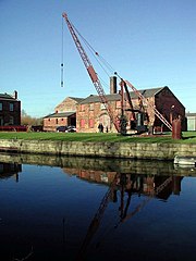
English: Thwaite Mills, near Leeds, West Yorkshire, England. Restored 18th century water-powered mill, previously used as fulling mill, putty grinding, etc. Now museum operated by Leeds City Council |
||
Date | |||
Source | https://www.geograph.org.uk/photo/333044 | ||
Author | Paul Glazzard | ||
Permission (Reusing this file) |
![]() ![]() ![]() This file is licensed under the Creative Commons Attribution-Share Alike 2.0 Generic license. Attribution: Paul Glazzard
|
||
Attribution (required by the license) InfoField | Paul Glazzard / Thwaite Mills, Stourton / | ||
InfoField | Paul Glazzard / Thwaite Mills, Stourton |
Camera location | 53° 46′ 33″ N, 1° 30′ 10″ W ![]() ![]() | View this and other nearby images on: OpenStreetMap | ![]() |
---|
Object location | 53° 46′ 34″ N, 1° 30′ 13″ W ![]() ![]() | View this and other nearby images on: OpenStreetMap | ![]() |
---|
File history
Click on a date/time to view the file as it appeared at that time.
Date/Time | Thumbnail | Dimensions | User | Comment | |
---|---|---|---|---|---|
current | 18:31, 30 October 2009 | ![]() | 480 × 640 (79 KB) | PamD (talk | contribs) | {{Information |Description={{en|1=Thwaite Mills, near Leeds, West Yorkshire, England. Restored 18th century water-powered mill, previously used as fulling mill, putty grinding, etc. Now museum operated by Leeds City Council}} |Source=http://www.geograph.o |
You cannot overwrite this file.
File usage on Commons
The following page uses this file:
File usage on other wikis
The following other wikis use this file:
- Usage on en.wikipedia.org
- Usage on en.wikivoyage.org
- Usage on it.wikivoyage.org
- Usage on www.wikidata.org
Metadata
This file contains additional information such as Exif metadata which may have been added by the digital camera, scanner, or software program used to create or digitize it. If the file has been modified from its original state, some details such as the timestamp may not fully reflect those of the original file. The timestamp is only as accurate as the clock in the camera, and it may be completely wrong.
Image title | OLYMPUS DIGITAL CAMERA |
---|---|
Camera manufacturer | OLYMPUS OPTICAL CO.,LTD |
Camera model | C3030Z |
Exposure time | 1/500 sec (0.002) |
F-number | f/4.5 |
ISO speed rating | 100 |
Date and time of data generation | 11:49, 7 February 2007 |
Lens focal length | 6.6 mm |
Orientation | Normal |
Horizontal resolution | 72 dpi |
Vertical resolution | 72 dpi |
Software used | v351p-77 |
File change date and time | 11:49, 7 February 2007 |
Y and C positioning | Co-sited |
Exposure Program | Normal program |
Exif version | 2.1 |
Date and time of digitizing | 11:49, 7 February 2007 |
Image compression mode | 5 |
APEX exposure bias | 0 |
Maximum land aperture | 3 APEX (f/2.83) |
Metering mode | Pattern |
Light source | Unknown |
Flash | Flash did not fire |
Color space | sRGB |
Structured data
Items portrayed in this file
depicts
7 February 2007
53°46'32.5"N, 1°30'10.4"W
53°46'34.14"N, 1°30'13.32"W
Hidden categories:
- CC-BY-SA-2.0
- Images from Geograph Britain and Ireland
- Images from Geograph Britain and Ireland missing SDC creator
- Images from Geograph Britain and Ireland missing SDC source of file
- Images from Geograph Britain and Ireland missing SDC MIME type
- Information field template with formatting
- Files with coordinates missing SDC location of creation (53° N, 2° W)
- United Kingdom photographs taken on 2007-02-07