File:Threlkeld Quarry & Mine Museum - passenger train (geograph 4586753).jpg
Threlkeld_Quarry_&_Mine_Museum_-_passenger_train_(geograph_4586753).jpg (640 × 427 pixels, file size: 80 KB, MIME type: image/jpeg)
Captions
Captions
Summary
[edit].jpg&action=edit§ion=1)
| Description |
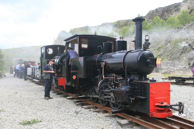
English: Threlkeld Quarry & Mine Museum - passenger train.
The steam gala was great fun and the atmosphere is hazy because of the smoke produced by no less than five locomotives and a steam excavator in the confines of the quarry floor at that time. This train had been hauled in by Hudswell, Clarke No. 1238 and Stanhope from the Apedale Valley Light Railway with Sir Tom, the site's indigenous engine, at the rear. Threlkeld Quarry and Mining MuseumThrelkeld Quarry, which is situated three miles east of Keswick, originally opened in 1870 to supply railway ballast to the Penrith-Keswick line. Later, the stone was used by the Manchester Corporation Waterworks for their Thirlmere scheme, for railway ballast for the Crewe-Carlisle line, for roadstone, kerbing and for facing buildings with dressed stone. The granite quarry finally closed in 1982 and is now the site for the Threlkeld Quarry & Mining Museum which is run by a group of volunteers. The extensive quarry site has ample space for the display of the unique collection of vintage excavators and old quarry machinery. The 2ft gauge mineral railway has been relaid and provides a ride into the inner quarry for visitors to view the quarry faces in safety. |
| Date | |
| Source | From geograph.org.uk |
| Author | Chris Allen |
| Permission (Reusing this file) |
Creative Commons Attribution Share-alike license 2.0 |
| Attribution (required by the license) | Chris Allen / Threlkeld Quarry & Mine Museum - passenger train / |
| Camera location | | View this and other nearby images on: OpenStreetMap |
|---|
.jpg¶ms=054.608451_N_-003.044390_E_globe:Earth_type:camera_heading:90.00_source:geograph&language=en)
| Object location | | View this and other nearby images on: OpenStreetMap |
|---|
.jpg¶ms=054.608500_N_-003.044000_E_globe:Earth_class:object_type:object_source:geograph-osgb36(NY32662420)_region:GB-GBN_heading:90.00&language=en)
Licensing
[edit].jpg&action=edit§ion=3)

|
This image was taken from the Geograph project collection. See this photograph's page on the Geograph website for the photographer's contact details. The copyright on this image is owned by Chris Allen and is licensed for reuse under the Creative Commons Attribution-ShareAlike 2.0 license.
|
- You are free:
- to share – to copy, distribute and transmit the work
- to remix – to adapt the work
- Under the following conditions:
- attribution – You must give appropriate credit, provide a link to the license, and indicate if changes were made. You may do so in any reasonable manner, but not in any way that suggests the licensor endorses you or your use.
- share alike – If you remix, transform, or build upon the material, you must distribute your contributions under the same or compatible license as the original.
File history
Click on a date/time to view the file as it appeared at that time.
| Date/Time | Thumbnail | Dimensions | User | Comment | |
|---|---|---|---|---|---|
| current | 07:07, 27 February 2016 | | 640 × 427 (80 KB) | NearEMPTiness (talk | contribs) | Transferred from geograph.co.uk using [https://tools.wmflabs.org/geograph2commons/ grograph2commons] |
You cannot overwrite this file.
File usage on Commons
The following page uses this file:
File usage on other wikis
The following other wikis use this file:
- Usage on de.wikipedia.org
- Usage on en.wikipedia.org
.jpg&oldid=901425259)