File:Three Sisters Fire Smokes ASTER 2012-09-19.png
Jump to navigation
Jump to search
Size of this preview: 800 × 533 pixels. Other resolutions: 320 × 213 pixels | 640 × 427 pixels | 1,024 × 683 pixels | 1,280 × 853 pixels | 2,429 × 1,619 pixels.
Original file (2,429 × 1,619 pixels, file size: 5.08 MB, MIME type: image/png)
Captions
Captions
Add a one-line explanation of what this file represents
Summary
[edit]
| Description |
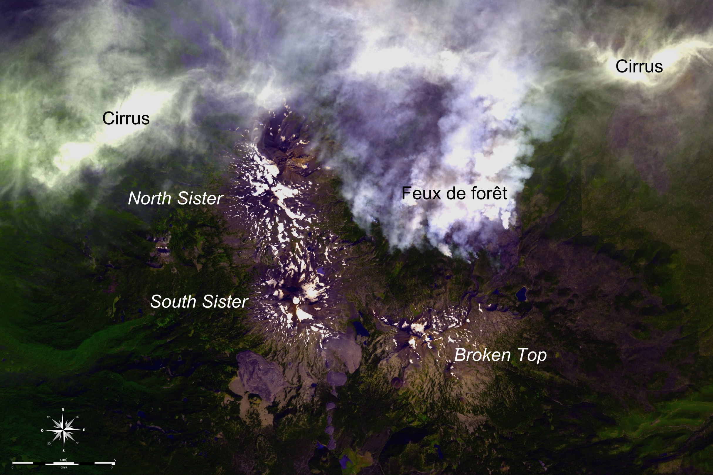
Français : Image satellite (programme ASTER) des Three Sisters, prise le 19 septembre 2012, montrant les fumées de l'incendie ayant sévi dans la zone de Pole Creek du 9 septembre au 20 octobre 2012 (d'après inciweb.
Deutsch: Satelliten image der Three Sisters.
English: Satellite image of Three Sisters, showing (in french) the smokes of the 2012 Pole Creek Fire (inciweb).
|
||
| Date | Taken on 20 October 2012 | ||
| Source |
Création personnelle ; USGS [1] ; |
||
| Author | © Bourrichon (talk) - fr:Bourrichon | ||
| Permission (Reusing this file) |
|
| Camera location | | View this and other nearby images on: OpenStreetMap |
|---|
Licensing
[edit]
I, the copyright holder of this work, hereby publish it under the following licenses:

|
Permission is granted to copy, distribute and/or modify this document under the terms of the GNU Free Documentation License, Version 1.2 or any later version published by the Free Software Foundation; with no Invariant Sections, no Front-Cover Texts, and no Back-Cover Texts. A copy of the license is included in the section entitled GNU Free Documentation License. |
This file is licensed under the Creative Commons Attribution-Share Alike 3.0 Unported, 2.5 Generic, 2.0 Generic and 1.0 Generic license.
- You are free:
- to share – to copy, distribute and transmit the work
- to remix – to adapt the work
- Under the following conditions:
- attribution – You must give appropriate credit, provide a link to the license, and indicate if changes were made. You may do so in any reasonable manner, but not in any way that suggests the licensor endorses you or your use.
- share alike – If you remix, transform, or build upon the material, you must distribute your contributions under the same or compatible license as the original.
You may select the license of your choice.
File history
Click on a date/time to view the file as it appeared at that time.
| Date/Time | Thumbnail | Dimensions | User | Comment | |
|---|---|---|---|---|---|
| current | 18:19, 28 April 2013 | | 2,429 × 1,619 (5.08 MB) | Bourrichon (talk | contribs) | rose des vents |
| 18:07, 28 April 2013 |  | 2,429 × 1,619 (5.09 MB) | Bourrichon (talk | contribs) | meilleure emprise | |
| 17:54, 28 April 2013 |  | 2,247 × 1,736 (5.06 MB) | Bourrichon (talk | contribs) | {{Location|44|06|13|N|121|46|10|W|scale:50000}} {{Information |Description= {{fr|Image satellite (programme ASTER) des fr:Three Sister, prise le 19 septembre 2012, montrant les fumées de l'incendie ayant sévi dans cette zone du 9 septembre au 2... |
You cannot overwrite this file.
File usage on Commons
The following page uses this file:
File usage on other wikis
The following other wikis use this file:
- Usage on fr.wikipedia.org