File:Thor's Hammer, Bryce Canyon National Park, Utah (2485746786).jpg

Original file (1,165 × 776 pixels, file size: 547 KB, MIME type: image/jpeg)
Captions
Captions
Summary
[edit].jpg&action=edit§ion=1)
| Description |
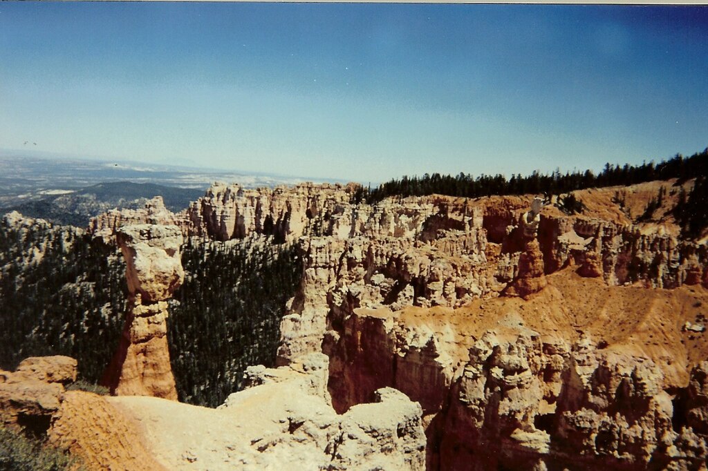
Thor's Hammer, a geological feature in Bryce Canyon National Park, which is located in southern Utah about 50 miles (80 km) northeast of—and 1,000 feet (300 m) higher than—Zion National Park. The weather in Bryce Canyon is therefore cooler, and the park receives more precipitation: a total of 15 to 18 inches (38 to 46 cm) per year. Yearly temperatures vary from an average minimum of 9 °F (−13 °C) in January to an average maximum of 83 °F (28 °C) in July, but extreme temperatures can range from −30 °F to 97 °F (−34 °C to 36 °C). The national park lies within the Colorado Plateau geographic province of North America and straddles the southeastern edge of the Paunsagunt Plateau west of the Paunsagunt Fault (Paunsagunt is Paiute for "home of the beaver"). Park visitors arrive from the plateau part of the park and look over the plateau's edge toward a valley containing the fault and the Paria River just beyond it (Paria is Paiute for "muddy or elk water"). The edge of the Kaiparowits Plateau bounds the opposite side of the valley. Bryce Canyon was not formed from erosion initiated from a central stream, meaning it technically is not a canyon. Instead headward erosion has excavated large amphitheater-shaped features in the Cenozoic-aged rocks of the Paunsagunt Plateau. This erosion exposed delicate and colorful pinnacles called hoodoos that are up to 200 feet (61 m) high. A series of amphitheaters extends more than 20 miles (32 km) north-to-south within the park. The largest is Bryce Amphitheater, which is 12 miles (19 km) long, 3 miles (4.8 km) wide and 800 feet (240 m) deep. A nearby example of amphitheaters with hoodoos in the same formation but at a higher elevation, is in Cedar Breaks National Monument, which is 25 miles (40 km) to the west on the Markagunt Plateau. Rainbow Point, the highest part of the park at 9,105 feet (2,775 m), is at the end of the 18-mile (29 km) scenic drive. From there, Aquarius Plateau, Bryce Amphitheater, the Henry Mountains, the Vermilion Cliffs and the White Cliffs can be seen. Yellow Creek, where it exits the park in the north-east section, is the lowest part of the park at 6,620 feet (2,020 m). Most park visitors sightsee using the scenic drive, which provides access to 13 viewpoints over the amphitheaters. Bryce Canyon has eight marked and maintained hiking trails that can be hiked in less than a day (round trip time, trailhead): Mossy Cave (one hour, State Route 12 northwest of Tropic), Rim Trail (5–6 hours, anywhere on rim), Bristlecone Loop (one hour, Rainbow Point), and Queens Garden (1–2 hours, Sunrise Point) are easy to moderate hikes. Navajo Loop (1–2 hours, Sunset Point) and Tower Bridge (2–3 hours, north of Sunrise Point) are moderate hikes. Fairyland Loop (4–5 hours, Fairyland Point) and Peekaboo Loop (3–4 hours, Bryce Point) are strenuous hikes. Several of these trails intersect, allowing hikers to combine routes for more challenging hikes. The park also has two trails designated for overnight hiking: the 9-mile (14 km) Riggs Loop Trail and the 23-mile (37 km) Under the Rim Trail. Both require a backcountry camping permit. In total there are 50 miles (80 km) of trails in the park. More than 10 miles (16 km) of marked but ungroomed skiing trails are available off of Fairyland, Paria, and Rim trails in the park. Twenty miles (32 km) of connecting groomed ski trails are in nearby Dixie National Forest and Ruby's Inn. The air in the area is so clear that on most days from Yovimpa and Rainbow points, Navajo Mountain and the Kaibab Plateau can be seen 90 miles (140 km) away in Arizona. On extremely clear days, the Black Mesas of eastern Arizona and western New Mexico can be seen some 160 miles (260 km) away. The park also has a 7.4 magnitude night sky, making it the one of the darkest in North America. Stargazers can therefore see 7,500 stars with the naked eye, while in most places fewer than 2,000 can be seen due to light pollution (in many large cities only a few dozen can be seen). Park rangers host public stargazing events and evening programs on astronomy, nocturnal animals, and night sky protection. The Bryce Canyon Astronomy Festival, typically held in June, attracts thousands of visitors. In honor of this astronomy festival, Asteroid 49272 was named after the national park. There are two campgrounds in the park, North Campground and Sunset Campground. Loop A in North Campground is open year-round. Additional loops and Sunset Campground are open from late spring to early autumn. The 114-room Bryce Canyon Lodge is another way to overnight in the park. A favorite activity of most visitors is landscape photography. With Bryce Canyon's high altitude and clean air, the sunrise and sunset photographs can be spectacular. <a href="http://en.wikipedia.org/wiki/Bryce_Canyon_National_Park" rel="nofollow">en.wikipedia.org/wiki/Bryce_Canyon_National_Park</a> |
| Date | |
| Source | Thor's Hammer, Bryce Canyon National Park, Utah |
| Author | Ken Lund from Reno, Nevada, USA |
| Camera location | | View this and other nearby images on: OpenStreetMap |
|---|
.jpg¶ms=037.516414_N_-112.264695_E_globe:Earth_type:camera_source:Flickr_&language=en)
Licensing
[edit].jpg&action=edit§ion=2)
- You are free:
- to share – to copy, distribute and transmit the work
- to remix – to adapt the work
- Under the following conditions:
- attribution – You must give appropriate credit, provide a link to the license, and indicate if changes were made. You may do so in any reasonable manner, but not in any way that suggests the licensor endorses you or your use.
- share alike – If you remix, transform, or build upon the material, you must distribute your contributions under the same or compatible license as the original.
| This image was originally posted to Flickr by Ken Lund at https://flickr.com/photos/75683070@N00/2485746786 (archive). It was reviewed on 7 August 2019 by FlickreviewR 2 and was confirmed to be licensed under the terms of the cc-by-sa-2.0. |
File history
Click on a date/time to view the file as it appeared at that time.
| Date/Time | Thumbnail | Dimensions | User | Comment | |
|---|---|---|---|---|---|
| current | 14:10, 7 August 2019 | | 1,165 × 776 (547 KB) | Jo-Jo Eumerus (talk | contribs) | Transferred from Flickr via #flickr2commons |
You cannot overwrite this file.
File usage on Commons
There are no pages that use this file.
.jpg&oldid=575748953)