File:Thonberg 1879.jpg
Jump to navigation
Jump to search

Size of this preview: 400 × 600 pixels. Other resolutions: 160 × 240 pixels | 320 × 480 pixels.
Original file (800 × 1,200 pixels, file size: 220 KB, MIME type: image/jpeg)
Captions
Captions
Add a one-line explanation of what this file represents
Summary
[edit]
| Description |
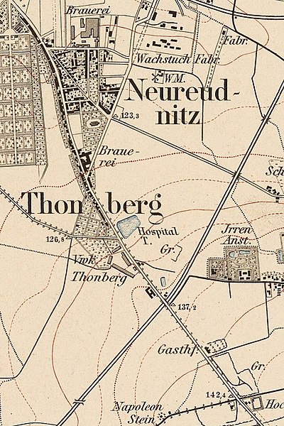
Deutsch: Thonberg auf einer Karte von 1879 (Topographische Karte Sachsen 1:25000 (Äquidistantenkarte), Ausschnitt von Blatt 11 (von 1879)) |
| Date |
1879 |
| Source |
Transferred from de.wikipedia to Commons. |
| Author |
Abteilung für Landesaufnahme des Königl. Sächs. Generalstabes. The original uploader was Martin Geisler at German Wikipedia. |
| Permission (Reusing this file) |
This image is in the public domain due to its age. |
Licensing
[edit]
This image (or other media file) is in the public domain because its copyright has expired and its author is anonymous.
This applies to the European Union and those countries with a copyright term of 70 years after the work was made available to the public and the author never disclosed their identity. Important: Always mention where the image comes from, as far as possible, and make sure the author never claimed authorship. Note: In Germany and possibly other countries, certain anonymous works published before July 1, 1995 are copyrighted until 70 years after the death of the author. See Übergangsrecht. Please use this template only if the author never claimed authorship or their authorship never became public in any other way. If the work is anonymous or pseudonymous (e.g., published only under a corporate or organization's name), use this template for images published more than 70 years ago.
For a work made available to the public in the United Kingdom, please use Template:PD-UK-unknown instead.
|
Original upload log
[edit]
The original description page was here. All following user names refer to de.wikipedia.
| Date/Time | Dimensions | User | Comment |
|---|---|---|---|
| 2022-05-24 10:54 | 800×1200× (225539 bytes) | Martin Geisler | heller |
| 2012-04-24 09:14 | 800×1200× (646009 bytes) | Martin Geisler | {{Information |Beschreibung = Thonberg auf einer Karte von 1879 (''Topographische Karte Sachsen 1:25000'' (Äquidistantenkarte), Ausschnitt von Blatt 11 (von 1879)) |Quelle = [http://deutschefotothek.de/?MEDIA_KARTEN&# Deutsche Fotothek -… |
File history
Click on a date/time to view the file as it appeared at that time.
| Date/Time | Thumbnail | Dimensions | User | Comment | |
|---|---|---|---|---|---|
| current | 12:14, 24 May 2022 | | 800 × 1,200 (220 KB) | Martin Geisler (talk | contribs) | Transferred from de.wikipedia via #commonshelper |
You cannot overwrite this file.
File usage on Commons
The following page uses this file:
File usage on other wikis
The following other wikis use this file:
- Usage on de.wikipedia.org