File:Thomas Bresson - Soufflerie (by).jpg
Jump to navigation
Jump to search

Size of this preview: 562 × 599 pixels. Other resolutions: 225 × 240 pixels | 450 × 480 pixels | 721 × 768 pixels | 961 × 1,024 pixels | 1,976 × 2,106 pixels.
Original file (1,976 × 2,106 pixels, file size: 3.26 MB, MIME type: image/jpeg)
Captions
Captions
Add a one-line explanation of what this file represents
Summary
[edit]| Description |
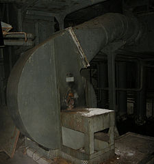
Soufflerie. Salbert hill fortifications. Old NATO station. Blower.This panoramic image was created with Autostitch (stitched images may differ from reality). |
||||||||||||||||||||||
| Date | |||||||||||||||||||||||
| Source | Fort du Salbert (ancien ouvrage "G" de la D.A.T. (OTAN)) | ||||||||||||||||||||||
| Author |
Thomas Bresson from Belfort, France
|
||||||||||||||||||||||

.jpg&action=edit§ion=1)
| Camera location | | View this and other nearby images on: OpenStreetMap |
|---|
.jpg¶ms=047.659894_N_0006.818583_E_globe:Earth_type:camera__&language=en)
Licensing
[edit].jpg&action=edit§ion=2)
This file is licensed under the Creative Commons Attribution 2.0 Generic license.
- You are free:
- to share – to copy, distribute and transmit the work
- to remix – to adapt the work
- Under the following conditions:
- attribution – You must give appropriate credit, provide a link to the license, and indicate if changes were made. You may do so in any reasonable manner, but not in any way that suggests the licensor endorses you or your use.
| This image was originally posted to Flickr by ComputerHotline at https://www.flickr.com/photos/36519414@N00/3401912798. It was reviewed on 1 April 2009 by FlickreviewR and was confirmed to be licensed under the terms of the cc-by-2.0. |
File history
Click on a date/time to view the file as it appeared at that time.
| Date/Time | Thumbnail | Dimensions | User | Comment | |
|---|---|---|---|---|---|
| current | 17:22, 31 March 2009 | | 1,976 × 2,106 (3.26 MB) | ComputerHotline (talk | contribs) | {{Information |Description= Soufflerie. Salbert hill fortifications. Old NATO station. Blower. |Source=[http://www.flickr.com/photos/36519414@N00/3401912798/ Fort du Salbert (ancien ouvrage "G" de la D.A.T. (OTAN))] |Date=March 31, 2009 at 14:21 |Author= |
You cannot overwrite this file.
File usage on Commons
The following page uses this file:
File usage on other wikis
The following other wikis use this file:
- Usage on fr.wikipedia.org
.jpg&oldid=845319529)