File:This Chart was Compiled on the Siberian Expedition under the Command of Navy Captain Bering from Tobolsk to the Chukotkan Corner WDL2572.png
Jump to navigation
Jump to search
Size of this preview: 800 × 350 pixels. Other resolutions: 320 × 140 pixels | 640 × 280 pixels | 1,024 × 448 pixels | 1,280 × 561 pixels | 2,338 × 1,024 pixels.
Original file (2,338 × 1,024 pixels, file size: 3.27 MB, MIME type: image/png)
Captions
Captions
Add a one-line explanation of what this file represents
Summary
[edit]
| Author |
Русский: Беринг, Витус Ионассен (1681-1741)
Français : Béring, Vitus Jonassen (1681-1741)
English: Bering, Vitus Jonassen (1681-1741)
中文:None
Português: Bering, Vitus Jonassen (1681-1741)
العربية: بيرنغ, فيتوس يوناسن (1681-1741)
Español: Bering, Vitus Jonassen (1681-1741) |
| Title |
Русский: Карта от Тобольска до мыса Чукотский составлена во время сибирской экспедиции под командованием капитана флота Беринга
Français : Cette carte fut dressée lors de l'expéditon sibérienne sous le commandement du capitaine de la marine Béring, entre Toboslk et la pointe de la Tchoukotka
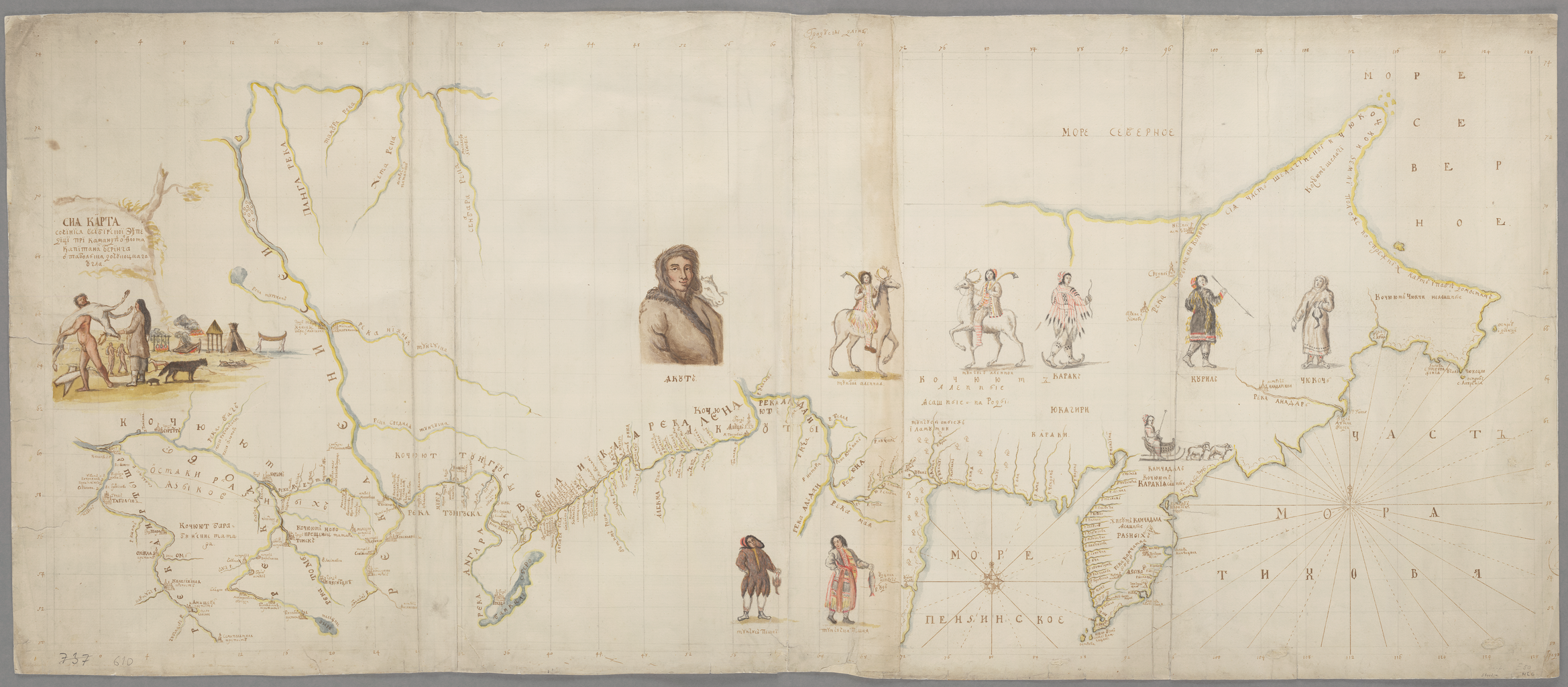
English: This Chart was Compiled on the Siberian Expedition under the Command of Navy Captain Bering from Tobolsk to the Chukotkan Corner
中文:神奇的语录:至爱启示录(使徒)
Português: Este Gráfico foi Compilado na Expedição da Sibéria sob o Comando do Capitão da Marinha Bering de Tobolsk ao extremo de Chukotkan
العربية: وضع هذا المخطط في خلال عمليات الاكتشاف السيبيري تحت قيادة الكابتن البحري بيرنغ من توبولسك إلى تشتكتكان كورنر
Español: Esta Mapa diseñado durante la Expedición a Siberia bajo el mando del capitán de navío Bering, desde Tobolsk hasta la península de Chukchi |
| Description |
Русский: Витус Ионассен Беринг (1681-1741 гг.) родился в Дании, но большую часть взрослой жизни посвятил российскому флоту. В 1725 г. царь Петр I (Петр Великий) поручил Берингу отправиться в экспедицию на поиски места, в котором Сибирь соединяется с Америкой. Экспедиция Беринга, известная как Первая Камчатская экспедиция (1725–1730 гг.), по суше добралась от Санкт-Петербурга через Тобольск до Камчатского полуострова, где было построено судно "Св. Гавриил". В 1728 г. он поплыл к северу вдоль берегов Камчатского полуострова. В августе того же года он прошел между двумя материками через пролив, впоследствии названный в его честь, но так и не достиг побережья Аляски и не смог установить, соединены ли Азия и Северная Америка или разделены водой. По возвращении в Санкт-Петербург Беринг преподнес императрице Анне (правившей в 1730-1740 гг.) карты, составленные в ходе экспедиции. В отличие от других карт экспедиции, этот эскиз карты содержит этнографическую информацию в виде нескольких первых изображений обитателей Сибири. На карте представлены такие народы, как якуты, коряки, чукчи, эвенки (ранее называвшиеся тунгусами или тунгузами), камчадалы (или ительмены), а также айны, населяющие Курильские острова. Вторая Камчатская экспедиция 1733-1743 гг., также возглавленная Берингом, завершилась в итоге открытием европейцами Аляски и подтверждением того, что Сибирь и Аляска действительно разделены водой.
Открытия и исследования; Коренные народности Français : Vitus Jonassen Béring (1681–1741) est né au Danemark, mais il a passé la plus grande partie de sa vie d'adulte dans la marine russe. En 1725, le Tsar Pierre Ier (Pierre le Grand) ordonna à Béring d'entreprendre une expédition afin de découvrir le point où la Sibérie était reliée à l'Amérique. Au cours de ce voyage, connu plus tard sous le nom de première expédition du Kamtchatka (1725-1730), Béring se rendit par voie de terre de Saint-Pétersbourg à Tobolsk, puis jusqu'à la péninsule du Kamtchatka, où il fit construire un navire : le Saint Gabriel. En 1728, il mit cap au nord le long de la côte de la péninsule du Kamtchatka. Au mois d'août de cette année-là, il passa entre les deux continents, empruntant le détroit qui porterait plus tard son nom, mais jamais il n'aperçut les côtes de l'Alaska et fut incapable de déterminer si l'Asie et l'Amérique du Nord étaient reliées ou séparées par la mer. De retour à Saint-Pétersbourg, Béring présenta à l'impératrice Anna (règne : 1730-1740) les cartes dressées au cours de l'expédition. À la différence des autres cartes de l'expédition, cette carte dessinée à la main comporte des dessins ethnographiques, comptant parmi les premières images des habitants de Sibérie. La carte représente notamment les peuples Yakoute, Koryak, Tchouktche, Evenk (nommé autrefois Toungouse), Kamtchadal (ou Itelmène), ainsi que le peuple Aïnou des îles Kouriles. La deuxième expédition du Kamtchatka de 1733-1743, également menée par Béring, conduit finalement à la découverte européenne de l'Alaska, confirmant ainsi que la Sibérie et l'Alaska étaient bien séparées par la mer.
Découverte et exploration; Peuples autochtones English: Vitus Jonassen Bering (1681–1741) was born in Denmark but spent most of his adult life in the Russian navy. In 1725, Tsar Peter I (Peter the Great) instructed Bering to undertake an expedition to find the point at which Siberia connected to America. In what became known as the First Kamchatka Expedition (1725–30), Bering traveled overland from St. Petersburg via Tobolsk to the Kamchatka Peninsula, where he had a ship, the Saint Gabriel, constructed. In 1728 he sailed north along the coast of the Kamchatka Peninsula. In August of that year he passed between the two continents through the strait that would later bear his name, but he never spotted the Alaskan coast and was unable to determine whether Asia and North America were connected or separated by water. Upon his return to St. Petersburg, Bering presented to Empress Anna (reigned 1730–40) the maps prepared during the expedition. Unlike other maps of the expedition, this hand-drawn map contains ethnographic drawings, some of the first images of the inhabitants of Siberia. Peoples represented on the map include the Yakuts, Koriaks, Chukchi, Evenks (formerly known as the Tungus or Tunguz), Kamchadal (or Itelmen), and the Ainu people of the Kuril Islands. The Second Kamchatka Expedition of 1733–43, also led by Bering, finally resulted in the European discovery of Alaska and confirmation that Siberia and Alaska were indeed separated by water.
Discovery and exploration; Indigenous peoples 中文:这本18世纪的手稿是对“启示录”(也被称作“圣约翰启示录”)的注释的一本副本,是 18 世纪作家尤素福·阿尔-巴尼名为神奇的语录:至爱启示录(使徒)的作品。 文本是用 Garshuni(用叙利亚字母写的阿拉伯语)书写的,书写非常清晰,但标题也在书的开篇处用阿拉伯文书写。 里面也有阿拉伯文的注释,例如,在第 3 页底部和第 4 页的边缘。 有标记显示这本书曾经被黎巴嫩科菲凡修道院拥有。 本书的印刷版在 1870 年于贝鲁特出版。
发现与探索; 土著居民 Português: Vitus Jonassen Bering (1681-1742) nasceu na Dinamarca mas passou a maior parte de sua vida adulta na marinha russa. Em 1725, o Czar Peter I (Pedro o Grande) instruiu Bering a proceder em uma expedição para encontrar o ponto onde a Sibéria se conectava à América. A qual ficou conhecida como a Primeira Expedição Kamchatka (1725-30), Bering viajou por terra de São Petersburgo via Tobolsk até a Península Kamchatka, onde ele tinha um navio, o São Gabriel, construído. Em 1728 ele navegou norte ao longo da costa da Península Kamchatka. Em agosto do mesmo ano ele passou pelos dois continentes através do estreito que mais tarde levaria seu nome, mas nunca encontrou a costa do Alasca e não conseguiu determinar se a Ásia e a América do Norte estavam conectadas ou separadas por água. Em seu retorno a São Petersburgo, Bering apresentou à Imperatriz Anna (reinado de 1730-40) os mapas preparados durante a expedição. Diferentemente de outros mapas de expedição, este mapa feito à mão contém desenhos etnográficos, algumas das primeiras imagens dos habitantes da Sibéria. As pessoas representadas no mapa incluem os Iacutos, Coriacos, Chukchis, Evenks (formalmente conhecidos como os Tungus ou Tunguz), Kamchadak (ou Itelmen), e o povo Ainu das Ilhas Curilas. A Segunda Expedição Kamchatka de 173-43, também liderada por Bering, finalmente resultou na descoberta europeia do Alasca e confirmação de que a Sibéria e o Alasca estavam realmente separados por água.
Descoberta e exploração; Povos indígenas العربية: ولد يوناسن فيتوس بيرنغ (1681-1741) في الدنمارك لكنه قضى معظم حياته في البحرية الروسية. في 1725، أمر القيصر بطرس الأول (بطرس الأكبر) بيرينغ بتجهيز حملة استكشافية للعثور على النقطة التي تتصل فيها سيبيريا بأمريكا. فيما أصبح يعرف باسم حملة كامْشاتْكا الأولى (1725-1730)، سافر بيرنغ من سانت بطرسبرغ عبر توبولسك الى شبه جزيرة كامْشاتْكا، حيث كان قد شيدت له سفينة هي سفينة القديس جبريل. في 1728، أبحر شمالاً على طول ساحل شبه جزيرة كامْشاتْكا. في أغسطس من ذلك العام اجتاز ما بين القارتين عبر المضيق الذي حمل اسمه فيما بعد، لكنه لم يرصد ساحل آلاسكا، ولم يكن قادرًا على تحديد ما إذا كانت آسيا وأمريكا الشمالية يرتبطان أم ينفصلان من خلال المياه. لدى عودته إلى سانت بطرسبرغ، قدم بيرينج إلى الإمبراطورة آنا (حكمت في الفترة من 1730-1740) الخرائط المعدة أثناء الرحلة. وخلاف خرائط الحملات الاستكشافية الأخرى، احتوت هذه الخريطة المرسومة باليد على رسومات للأعراق البشرية، وبعض من الصور الأولى لسكان سيبيريا. شملت الشعوب والأعراق الممثلة على خريطة الياقوت والكوريانز والتشوكشي والإيفانكس (المعروفة سابقا باسم تونجيوس أو Tunguz)، كومتشادل (أو إتلمن)، وشعب آينو في جزر الكوريل. قاد بيرنغ حملة كامْشاتْكا الثانية 1733-1743 أيضًا، وتمخضت في نهاية المطاف عن الاكتشاف الأوروبي لآلاسكا وتأكيد حقيقة أن سيبيريا وألاسكا تفصلهما المياه.
الاكتشاف والاستكشاف; الشعوب الأصلية Español: Vitus Jonassen Bering (1681–1741) nació en Dinamarca pero pasó la mayor parte de su vida adulta en la armada rusa. En 1725, el zar Pedro I (Pedro el Grande) encargó a Bering que llevara a cabo una expedición para encontrar el punto en que Siberia se unía a América. En lo que se conoció como la Primera expedición a Kamchatka (1725-1730), Bering viajó por tierra desde San Petersburgo a través de Tobolsk, hacia la península de Kamchatka, donde hizo construir un barco, el San Gabriel. En 1728, navegó hacia el norte bordeando la península de Kamchatka. En agosto de ese año pasó entre los dos continentes a través del estrecho que más tarde llevaría su nombre, pero nunca vio la costa de Alaska y fue incapaz de determinar si Asia y América del Norte estaban conectadas o separadas por el agua. A su regreso a San Petersburgo, Bering presentó a la emperatriz Ana (que reinó de 1730 a 1740) los mapas preparados durante la expedición. A diferencia de otros mapas de la expedición, este mapa dibujado a mano contiene dibujos etnográficos: algunas de las primeras imágenes de los habitantes de Siberia. Los pueblos representados en el mapa son los yakutos, koriaks, chukchi, evencos (antes conocidos como los tungus o tunguz), kamchadal (o itelmen), y el pueblo ainu de las Islas Kuriles. La Segunda expedición a Kamchatka (1733-1743), también liderada por Bering, finalmente llevó al descubrimiento de Alaska por parte de Europa, y la confirmación de que Siberia y Alaska estaban efectivamente separadas por el agua.
Descubrimiento y exploración; Pueblos indígenas |
| Date | between 1725 and 1730 |
| Medium |
Русский: Карты
Français : Cartes
English: Maps
中文:地图
Português: Mapas
العربية: خرائط
Español: Mapas |
| Dimensions |
English: 1 handdrawn map ; 52 x 130 centimeters |
| Collection |
Русский: Национальная библиотека Швеции
Français : Bibliothèque nationale de Suède
English: National Library of Sweden
中文:瑞典国家图书馆
Português: Biblioteca Nacional da Suécia
العربية: مكتبة السويد الوطنية
Español: Biblioteca Nacional de Suecia |
| Place of creation |
Русский: Российская Федерация
Français : Fédération de Russie
English: Russian Federation
中文:俄罗斯联邦
Português: Federação Russa
العربية: الاتحاد الروسي
Español: Federación de Rusia |
| Notes | Original language title: Сия харта сочинися в сибирской экспедиции при команде от флота капитана Беринга от Тобольска до Чукотского [Цокоцкого] угла |
| Source/Photographer |
|
Licensing
[edit]
|
This is a faithful photographic reproduction of a two-dimensional, public domain work of art. The work of art itself is in the public domain for the following reason:
The official position taken by the Wikimedia Foundation is that "faithful reproductions of two-dimensional public domain works of art are public domain".
This photographic reproduction is therefore also considered to be in the public domain in the United States. In other jurisdictions, re-use of this content may be restricted; see Reuse of PD-Art photographs for details. | ||||
File history
Click on a date/time to view the file as it appeared at that time.
| Date/Time | Thumbnail | Dimensions | User | Comment | |
|---|---|---|---|---|---|
| current | 05:45, 11 March 2014 | | 2,338 × 1,024 (3.27 MB) | Fæ (talk | contribs) | =={{int:filedesc}}== {{Artwork |artist = |author ={{ru|1=Беринг, Витус Ионассен (1681-1741)}} {{fr|1=Béring, Vitus Jonassen (1681-1741)}} {{en|1=Bering, Vitus Jonassen (1681-1741)}} {{zh|1=None}} {{pt|1=Bering, Vitus Jonassen (1681-... |
You cannot overwrite this file.
File usage on Commons
The following 3 pages use this file: