File:Thirlmerelakemap.jpg
Jump to navigation
Jump to search
No higher resolution available.
Thirlmerelakemap.jpg (290 × 594 pixels, file size: 33 KB, MIME type: image/jpeg)
Captions
Captions
Add a one-line explanation of what this file represents
Summary
[edit]
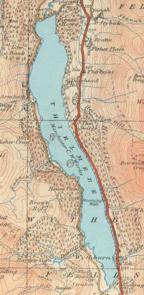
Thirlmere on a 1925 Ordnance Survey map
- This work is in the public domain because it is an Ordnance Survey map over 50 years old. Ordnance Survey maps are covered by crown copyright which in this case expires 50 years after publication. Ordnance Survey does however ask that they be credited and that the date of publication be given. Any ancillary rights gained through the creation of the electronic version are granted as freely usable under any circumstances.
Licensing
[edit]
|
This is a faithful photographic reproduction of a two-dimensional, public domain work of art. The work of art itself is in the public domain for the following reason:
The official position taken by the Wikimedia Foundation is that "faithful reproductions of two-dimensional public domain works of art are public domain". This photographic reproduction is therefore also considered to be in the public domain in the United States. In other jurisdictions, re-use of this content may be restricted; see Reuse of PD-Art photographs for details. {{PD-Art}} template without license parameter: please specify why the underlying work is public domain in both the source country and the United States
(Usage: {{PD-Art|1=|deathyear=''year of author's death''|country=''source country''}}, where parameter 1= can be PD-old-auto, PD-old-auto-expired, PD-old-auto-1996, PD-old-100 or similar. See Commons:Multi-license copyright tags for more information.) | ||||
File history
Click on a date/time to view the file as it appeared at that time.
| Date/Time | Thumbnail | Dimensions | User | Comment | |
|---|---|---|---|---|---|
| current | 22:23, 17 October 2006 | | 290 × 594 (33 KB) | Voyager (talk | contribs) | == Summary == Thirlmere on a 1925 Ordnance Survey map :This work is in the public domain because it is an Ordnance Survey map over 50 years old. Ordnance Survey maps are covered by crown copyright which in this case expires 50 years after publication. Or |
You cannot overwrite this file.
File usage on Commons
The following page uses this file:
File usage on other wikis
The following other wikis use this file: