File:Third world countries map world 2.PNG
Jump to navigation
Jump to search

Size of this preview: 800 × 397 pixels. Other resolutions: 320 × 159 pixels | 640 × 318 pixels | 1,024 × 508 pixels | 1,280 × 635 pixels | 2,560 × 1,271 pixels | 4,500 × 2,234 pixels.
Original file (4,500 × 2,234 pixels, file size: 240 KB, MIME type: image/png)
Captions
Captions
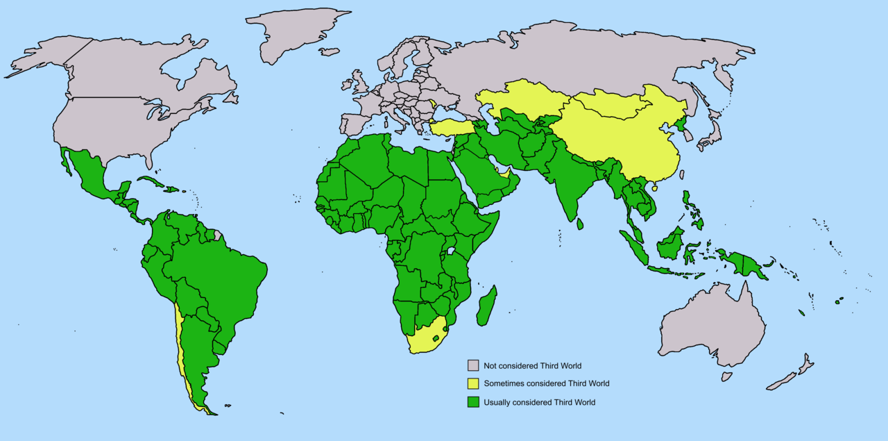
First, Second and Third World Countries
 Please be aware that this map is of no use for an encyclopedia. Do not use it in any Wikipedia article! See [1] for further reference.
![[1]](https://web.archive.org/web/20061110102046/http://commons.wikimedia.org/wiki/Image_talk:Third_world_world_map_transparent.png)
Summary
[edit]
Green is usually considered third world; Yellow is sometimes considered third world, map made by me
older version of the map here
Licensing
[edit]

|
Permission is granted to copy, distribute and/or modify this document under the terms of the GNU Free Documentation License, Version 1.2 or any later version published by the Free Software Foundation; with no Invariant Sections, no Front-Cover Texts, and no Back-Cover Texts. A copy of the license is included in the section entitled GNU Free Documentation License. |
| This file is licensed under the Creative Commons Attribution-Share Alike 3.0 Unported license. | ||
| ||
| This licensing tag was added to this file as part of the GFDL licensing update. |
File history
Click on a date/time to view the file as it appeared at that time.
| Date/Time | Thumbnail | Dimensions | User | Comment | |
|---|---|---|---|---|---|
| current | 13:57, 15 March 2022 | | 4,500 × 2,234 (240 KB) | Octopixy (talk | contribs) | south sudan |
| 11:46, 15 December 2018 |  | 4,500 × 2,234 (289 KB) | NikitaThe No (talk | contribs) | Reverted to version as of 20:40, 25 August 2018 (UTC) | |
| 08:22, 15 December 2018 |  | 4,096 × 2,033 (2.3 MB) | NikitaThe No (talk | contribs) | Reverted to version as of 04:50, 23 October 2018 (UTC) | |
| 22:42, 10 December 2018 |  | 4,500 × 2,234 (240 KB) | JGaines1988 (talk | contribs) | New Caledonia, South Africa | |
| 22:40, 10 December 2018 |  | 4,500 × 2,234 (240 KB) | JGaines1988 (talk | contribs) | Reverted to version as of 13:43, 25 September 2018 (UTC) | |
| 04:50, 23 October 2018 |  | 4,096 × 2,033 (2.3 MB) | NikitaThe No (talk | contribs) | Sweden | |
| 13:43, 25 September 2018 |  | 4,500 × 2,234 (240 KB) | Illslidia (talk | contribs) | Sweden, South Africa, Bahrain | |
| 20:40, 25 August 2018 |  | 4,500 × 2,234 (289 KB) | Illslidia (talk | contribs) | Update | |
| 01:43, 14 January 2006 |  | 4,500 × 2,234 (218 KB) | Roke~commonswiki (talk | contribs) | argentina, uruguay, chile, panama, costa rica, turkey, some arab states marked as possibly third world after discussion | |
| 11:58, 29 November 2005 |  | 1,265 × 629 (33 KB) | Roke~commonswiki (talk | contribs) | Green is usually considered third world; Yellow is sometimes considered third world, map made by me |
You cannot overwrite this file.
File usage on Commons
There are no pages that use this file.
File usage on other wikis
The following other wikis use this file:
- Usage on cs.wikipedia.org
- Usage on da.wikipedia.org
- Usage on en.wikipedia.org
- Usage on en.wikiquote.org
- Usage on eo.wikiquote.org
- Usage on fo.wikipedia.org
- Usage on incubator.wikimedia.org
- Usage on ja.wikipedia.org
- Usage on nn.wikipedia.org
- Usage on no.wikipedia.org
- Usage on sv.wikipedia.org
- Usage on uk.wikipedia.org