File:The plot of Carroll'sburgh - (part of Washington D.C.). LOC 88690858.jpg
Jump to navigation
Jump to search

Size of this preview: 800 × 500 pixels. Other resolutions: 320 × 200 pixels | 640 × 400 pixels | 1,024 × 641 pixels | 1,280 × 801 pixels | 2,560 × 1,601 pixels | 7,060 × 4,416 pixels.
Original file (7,060 × 4,416 pixels, file size: 3.54 MB, MIME type: image/jpeg)
Captions
Captions
Add a one-line explanation of what this file represents
Summary
[edit]| Description |
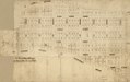
English: Cadastral survey map showing lot numbers. Pen-and-ink. Oriented with north toward the upper right. Torn and fold-lined. Accompanied by index of lots: List of the original proprietors of the lots in Carrollsburg, with the numbers ... [6] p. : ms. ; 64 x 21 cm. or smaller, folded in leather binder 36 x 23 cm. Available also through the Library of Congress Web site as a raster image. Phillips. Washington, 353 Vault DCP |
||
| Title | The plot of Carroll'sburgh : [part of Washington D.C.]. | ||
| Shelf ID | G3852.C35 179- .P5 | ||
| Date | |||
| Source | https://www.loc.gov/item/88690858/ | ||
| Author | Unknown author | ||
| Permission (Reusing this file) |
|
||
| Other versions |
|
||
| Location | United States · Washington D.C. · District Of Columbia · Washington · Carrollsburg | ||
| Part of | American Memory · Cities And Towns · Catalog · Geography And Map Division | ||
| Subject | Maps, Manuscript · Surveys · Washington (D.C.) · Washington · United States · Maps · Early Works To 1800 · District Of Columbia · Carrollsburg (Washington, D.C.) · Carrollsburg · Real Property · Manuscript Maps |

._LOC_88690858.jpg&action=edit§ion=1)
Licensing
[edit]._LOC_88690858.jpg&action=edit§ion=2)
|
This is a faithful photographic reproduction of a two-dimensional, public domain work of art. The work of art itself is in the public domain for the following reason:
The official position taken by the Wikimedia Foundation is that "faithful reproductions of two-dimensional public domain works of art are public domain".
This photographic reproduction is therefore also considered to be in the public domain in the United States. In other jurisdictions, re-use of this content may be restricted; see Reuse of PD-Art photographs for details. | ||||
File history
Click on a date/time to view the file as it appeared at that time.
| Date/Time | Thumbnail | Dimensions | User | Comment | |
|---|---|---|---|---|---|
| current | 03:47, 19 May 2018 | | 7,060 × 4,416 (3.54 MB) | Fæ (talk | contribs) | LOC Maps https://www.loc.gov/item/88690858/ #11139 |
You cannot overwrite this file.
File usage on Commons
The following page uses this file:
._LOC_88690858.jpg&oldid=450925365)