File:The navigator - containing directions for navigating the Monongahela, Allegheny, Ohio and Mississippi rivers; with an ample account of these much admired waters, from the head of the former to the (14781564614).jpg

Original file (2,848 × 1,340 pixels, file size: 700 KB, MIME type: image/jpeg)
Captions
Captions
Summary
[edit].jpg&action=edit§ion=1)
| Description |
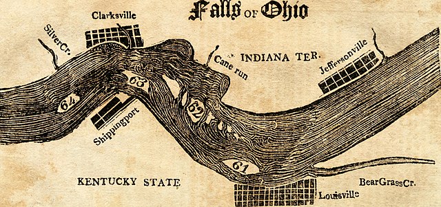
English: Identifier: navigatorcontai1821cram (find matches) |
| Date | |
| Source |
https://www.flickr.com/photos/internetarchivebookimages/14781564614/ |
| Author | Cramer, Zadok, 1773-1813? |
| Permission (Reusing this file) |
At the time of upload, the image license was automatically confirmed using the Flickr API. For more information see Flickr API detail. |
| Flickr tags |
|
| Flickr posted date | 30 July 2014 |
Licensing
[edit].jpg&action=edit§ion=2)
This image was taken from Flickr's The Commons. The uploading organization may have various reasons for determining that no known copyright restrictions exist, such as:
More information can be found at https://flickr.com/commons/usage/. Please add additional copyright tags to this image if more specific information about copyright status can be determined. See Commons:Licensing for more information. |
| This image was originally posted to Flickr by Internet Archive Book Images at https://flickr.com/photos/126377022@N07/14781564614. It was reviewed on 24 August 2015 by FlickreviewR and was confirmed to be licensed under the terms of the No known copyright restrictions. |
File history
Click on a date/time to view the file as it appeared at that time.
| Date/Time | Thumbnail | Dimensions | User | Comment | |
|---|---|---|---|---|---|
| current | 04:02, 30 September 2018 | | 2,848 × 1,340 (700 KB) | SteinsplitterBot (talk | contribs) | Bot: Image rotated by 90° |
| 06:14, 24 August 2015 |  | 1,340 × 2,860 (704 KB) | Fæ (talk | contribs) | == {{int:filedesc}} == {{information |description={{en|1=<br> '''Identifier''': navigatorcontai1821cram ([https://commons.wikimedia.org/w/index.php?title=Special%3ASearch&profile=default&fulltext=Search&search=insource%3A%2Fnavigatorcontai1821cram%2F f... |
You cannot overwrite this file.
File usage on Commons
There are no pages that use this file.
.jpg&oldid=882836288)
- The navigator - containing directions for navigating the Monongahela, Allegheny, Ohio and Mississippi Rivers
- Maps of the Falls of the Ohio
- 1820s maps of Kentucky
- 1820s maps of Indiana
- Maps of Louisville, Kentucky
- Old maps of Jefferson County, Kentucky
- Maps of Clarksville, Indiana
- Jeffersonville, Indiana in the 1820s