File:The heat is on ESA19461898.jpeg

Original file (6,093 × 5,528 pixels, file size: 19.27 MB, MIME type: image/jpeg)
Captions
Captions
Summary
[edit]| Description |
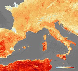
English: With some places expecting to be hit with air temperatures of over 40°C in the next days, much of Europe is in the grip of a heatwave – and one that is setting record highs for June. According to meteorologists this current bout of sweltering weather is down to hot air being drawn from north Africa.
This map shows the temperature of the land on 26 June. It has been generated using information from the Copernicus Sentinel-3’s Sea and Land Surface Temperature Radiometer, which measures energy radiating from Earth’s surface in nine spectral bands – the map therefore represents temperature of the land surface, not air temperature which is normally used in forecasts. The white areas in the image are where cloud obscured readings of land temperature and the light blue patches are either low temperatures at the top of cloud or snow-covered areas. Countries worst hit by this unusual June weather include Spain, France, Germany, Italy and Poland. In many places heat warnings have been issued and cities such as Paris have connected fountains and sprinklers to hydrants to help give people some relief. Wildfires in Catalonia, said to be the worst in two decades, have already ripped across 5000 hectares of land and are being blamed on the heat and strong winds. Français : Alors que certains endroits s'attendent à être frappés par des températures de l'air de plus de 40 ° C dans les prochains jours, une grande partie de l'Europe est en proie à une vague de chaleur - et qui établit des records pour juin. Selon les météorologues, l'épisode actuel de temps étouffant est dû à l'air chaud provenant de l'Afrique du Nord.
Cette carte montre la température de la terre le 26 juin 2019. Il a été généré à l'aide des informations du radiomètre de température de surface de la mer et de la terre de Copernicus Sentinel-3, qui mesure l'énergie rayonnant de la surface de la Terre dans neuf bandes spectrales - la carte représente donc la température de la surface terrestre, et non la température de l'air qui est normalement utilisée dans les prévisions. . Les zones blanches de l'image correspondent aux endroits où les nuages obscurcissent les lectures de la température terrestre et les taches bleu clair représentent soit des températures basses au sommet des nuages, soit des zones couvertes de neige. Les pays les plus touchés par ce temps inhabituel de juin sont l'Espagne, la France, l'Allemagne, l'Italie et la Pologne. Dans de nombreux endroits, des avertissements de chaleur ont été émis et des villes comme Paris ont connecté des fontaines et des gicleurs aux bouches d'incendie pour aider à soulager les gens. Les incendies de forêt en Catalogne, qui seraient les pires depuis deux décennies, ont déjà ravagé 5000 hectares de terres et sont imputés à la chaleur et aux vents violents |
| Date | 27 June 2019 (upload date) |
| Source | The heat is on |
| Author | European Space Agency |
| Other versions |
|
| Activity | Observing the Earth |
| Mission | Sentinel-3 |
| System | Copernicus |


Licensing
[edit]

|
This image contains data from a satellite in the Copernicus Programme, such as Sentinel-1, Sentinel-2 or Sentinel-3. Attribution is required when using this image.
Attribution: Contains modified Copernicus Sentinel data 2019
The use of Copernicus Sentinel Data is regulated under EU law (Commission Delegated Regulation (EU) No 1159/2013 and Regulation (EU) No 377/2014). Relevant excerpts:
Free access shall be given to GMES dedicated data [...] made available through GMES dissemination platforms [...].
Access to GMES dedicated data [...] shall be given for the purpose of the following use in so far as it is lawful:
GMES dedicated data [...] may be used worldwide without limitations in time.
GMES dedicated data and GMES service information are provided to users without any express or implied warranty, including as regards quality and suitability for any purpose. |
This media was created by the European Space Agency (ESA).
Where expressly so stated, images or videos are covered by the Creative Commons Attribution-ShareAlike 3.0 IGO (CC BY-SA 3.0 IGO) licence, ESA being an Intergovernmental Organisation (IGO), as defined by the CC BY-SA 3.0 IGO licence. The user is allowed under the terms and conditions of the CC BY-SA 3.0 IGO license to Reproduce, Distribute and Publicly Perform the ESA images and videos released under CC BY-SA 3.0 IGO licence and the Adaptations thereof, without further explicit permission being necessary, for as long as the user complies with the conditions and restrictions set forth in the CC BY-SA 3.0 IGO licence, these including that:
See the ESA Creative Commons copyright notice for complete information, and this article for additional details.
|
 | |
This file is licensed under the Creative Commons Attribution-ShareAlike 3.0 IGO license. Attribution: ESA, CC BY-SA IGO 3.0
| ||
File history
Click on a date/time to view the file as it appeared at that time.
| Date/Time | Thumbnail | Dimensions | User | Comment | |
|---|---|---|---|---|---|
| current | 21:11, 20 June 2020 | | 6,093 × 5,528 (19.27 MB) | OptimusPrimeBot (talk | contribs) | #Spacemedia - Upload of https://www.esa.int/var/esa/storage/images/esa_multimedia/images/2019/06/the_heat_is_on/19461888-4-eng-GB/The_heat_is_on.jpg via Commons:Spacemedia |
You cannot overwrite this file.
File usage on Commons
The following 4 pages use this file:
.jpg&redirect=no)
File usage on other wikis
The following other wikis use this file:
- Usage on az.wikipedia.org
- Usage on be.wikipedia.org
- Usage on dag.wikipedia.org
- Usage on en.wikipedia.org
- Usage on eo.wikipedia.org
- Usage on ko.wikipedia.org
- Usage on mt.wikipedia.org
- Usage on pt.wikipedia.org
- Usage on ro.wikipedia.org
- Usage on rw.wikipedia.org
- Usage on tr.wikipedia.org
- Usage on tt.wikipedia.org
- Usage on vi.wikipedia.org
- Usage on www.wikidata.org
Metadata
- June 2019 European heat wave
- Satellite pictures of Europe
- Sentinel-3 images
- Land surface temperature maps
- Weather maps of Africa
- Weather and climate of Algeria
- Weather phenomena in Tunisia
- Weather and climate of Morocco
- Weather and climate of Spain
- Weather and climate of France
- Weather and climate of Italy
- Weather and climate of Germany