File:The geology of New Hampshire - a report comprising the results of explorations ordered by the legislature (1874) (14784075002).jpg

From Wikimedia Commons, the free media repository
Jump to navigation Jump to search

Original file(2,112 × 3,204 pixels, file size: 897 KB, MIME type: image/jpeg)

Captions

Captions

Add a one-line explanation of what this file represents

Summary

[edit]
Description
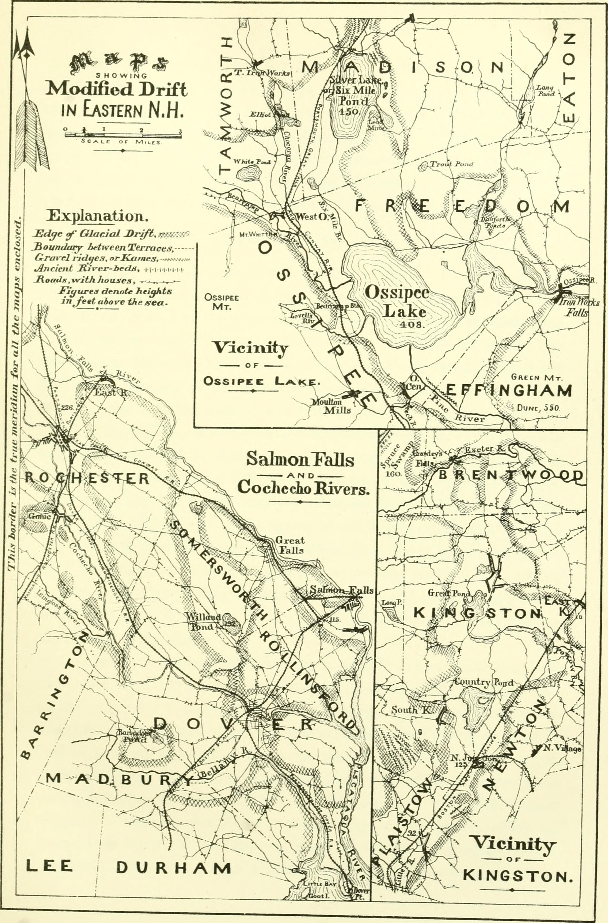
English:

Identifier: geologyofnewhamp35newh (find matches)
Title: The geology of New Hampshire : a report comprising the results of explorations ordered by the legislature
Year: 1874 (1870s)
Authors: New Hampshire. Geological and Mineralogical Survey Hitchcock, Charles H. (Charles Henry), 1836-1919 Upham, Warren, 1850-1934 Huntington, Joshua Henry, 1833-1904 Quimby, Elihu T. (Elihu Thayer), 1826-1890 Scudder, Samuel Hubbard, 1837-1911 Flint, William F Edwards, Arthur M. (Arthur Mead) Hawes, George Wesson, 1848-1882
Subjects: Geology Rivers Insects Botany Fragilariaceae Drift Mineralogy Physical geography
Publisher: Concord : E. A. Jenks, state printer
Contributing Library: University of New Hampshire Library
Digitizing Sponsor: University of New Hampshire Library

View Book Page: Book Viewer
About This Book: Catalog Entry
View All Images: All Images From Book
Click here to view book online to see this illustration in context in a browseable online version of this book.

Text Appearing Before Image:
one foot in diameter, is occasionallyfound, and appears to belong to kames which have been nearly buriedbeneath the fine alluvium. Ossipee river, the outlet of this lake, flows over till at Effingham falls,and along its last mile before entering Maine. In the intervening threemiles it is bordered by low modified drift, which extends to Swasey pondin Freedom, and forms an extensive tamarack swamp in the north-eastcorner of Effingham. On the west and south sides of Ossipee lake the modified drift is onehalf mile to a mile and a half wide. Its highest portion is a delta-plain onthe north side of Lovells river, 40 feet above the lake. Elsewhere it islow, being swampy in many places, and rises only 15 to 25 feet above thelake, towards which it slopes. These nearly level areas are bounded by hills and mountains, whichrise steeply from the edge of the plains. The supply of modified driftwas very abundant here, and fills three fourths of the natural lake-basinwhich is thus enclosed. PlateVr.
Text Appearing After Image:
MODIFIED DRIFT ALONG PINE RIVER. I47 A conspicuous dune, blown 125 feet above the low plains, occurs twomiles south-east from Ossipee lake on the west foot-slope of Green moun-tain. A track of sancl-drifts, now grassed over, reaches up to this fromthe north-west; and an old pine stump, standing where it originallygrew, shows that since the clearing of the country a portion of the duneseven feet in depth has been swept from beneath it by the winds, beingcarried to the south-east and somewhat higher up the hillside. Kamcs along Pine River. South-east from Ossipee lake a continuous belt of modified drift ex-tends along the entire course of Pine river, forms the water-shed betweenPine River pond and Balch pond, and thence continues eastward alongLittle Ossipee river in Maine. These ponds are about 20 and 40 feetrespectively below the lowest point of the water-shed, which is about 550feet above the sea, or 140 above Ossipee lake, 12 miles distant. Thewidth of the modified drift here is ful

Note About Images

Please note that these images are extracted from scanned page images that may have been digitally enhanced for readability - coloration and appearance of these illustrations may not perfectly resemble the original work.
Date
Source

https://www.flickr.com/photos/internetarchivebookimages/14784075002/

Author

New Hampshire. Geological and Mineralogical Survey; Hitchcock, Charles H. (Charles Henry), 1836-1919; Upham, Warren, 1850-1934; Huntington, Joshua Henry, 1833-1904; Quimby, Elihu T. (Elihu Thayer), 1826-1890; Scudder, Samuel Hubbard, 1837-1911; Flint, William F; Edwards, Arthur M. (Arthur Mead);

Hawes, George Wesson, 1848-1882
Permission
(Reusing this file)
At the time of upload, the image license was automatically confirmed using the Flickr API. For more information see Flickr API detail.
Flickr tags
InfoField
Flickr posted date
InfoField
30 July 2014


Licensing

[edit]
This image was taken from Flickr's The Commons. The uploading organization may have various reasons for determining that no known copyright restrictions exist, such as:
  1. The copyright is in the public domain because it has expired;
  2. The copyright was injected into the public domain for other reasons, such as failure to adhere to required formalities or conditions;
  3. The institution owns the copyright but is not interested in exercising control; or
  4. The institution has legal rights sufficient to authorize others to use the work without restrictions.

More information can be found at https://flickr.com/commons/usage/.


Please add additional copyright tags to this image if more specific information about copyright status can be determined. See Commons:Licensing for more information.
This image was originally posted to Flickr by Internet Archive Book Images at https://flickr.com/photos/126377022@N07/14784075002. It was reviewed on 19 August 2015 by FlickreviewR and was confirmed to be licensed under the terms of the No known copyright restrictions.

19 August 2015

File history

Click on a date/time to view the file as it appeared at that time.

Date/TimeThumbnailDimensionsUserComment
current21:20, 19 August 2015Thumbnail for version as of 21:20, 19 August 20152,112 × 3,204 (897 KB) (talk | contribs)== {{int:filedesc}} == {{information |description={{en|1=<br> '''Identifier''': geologyofnewhamp35newh ([https://commons.wikimedia.org/w/index.php?title=Special%3ASearch&profile=default&fulltext=Search&search=insource%3A%2Fgeologyofnewhamp35newh%2F fin...

There are no pages that use this file.