File:The disused quarry at Burdale - geograph.org.uk - 1388389.jpg
Jump to navigation
Jump to search
No higher resolution available.
The_disused_quarry_at_Burdale_-_geograph.org.uk_-_1388389.jpg (640 × 480 pixels, file size: 82 KB, MIME type: image/jpeg)
Captions
Captions
Add a one-line explanation of what this file represents
Summary
[edit]
| Description |
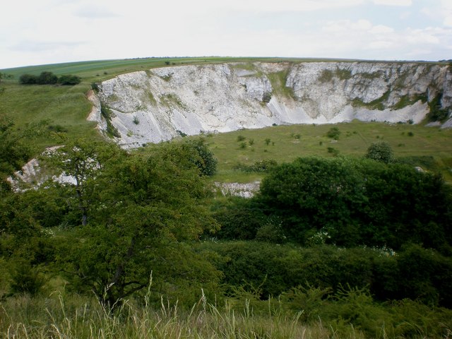
English: The disused quarry at Burdale. This photo, taken from the roadside, shows the northern half of disused Burdale Quarry along the site of the old Driffield to Malton railway. The limestone quarry was opened in 1925, was the largest in the area and at its most productive after World War II. However, by 1952 it was in decline and production eventually ceased in 1955. The loss of this important freight traffic consequently resulted in closure of the railway in 1958. The quarry is designated a Regionally Important Geological and Geomorphological Site within East Yorkshire. |
| Date | |
| Source | From geograph.org.uk |
| Author | Dr Patty McAlpin |
| Permission (Reusing this file) |
Creative Commons Attribution Share-alike license 2.0 |
| Attribution (required by the license) | Dr Patty McAlpin / The disused quarry at Burdale / |
| Camera location | | View this and other nearby images on: OpenStreetMap |
|---|
_heading:112.00&language=en)
| Object location | | View this and other nearby images on: OpenStreetMap |
|---|
_heading:112.00&language=en)
Licensing
[edit]

|
This image was taken from the Geograph project collection. See this photograph's page on the Geograph website for the photographer's contact details. The copyright on this image is owned by Dr Patty McAlpin and is licensed for reuse under the Creative Commons Attribution-ShareAlike 2.0 license.
|
This file is licensed under the Creative Commons Attribution-Share Alike 2.0 Generic license.
Attribution: Dr Patty McAlpin
- You are free:
- to share – to copy, distribute and transmit the work
- to remix – to adapt the work
- Under the following conditions:
- attribution – You must give appropriate credit, provide a link to the license, and indicate if changes were made. You may do so in any reasonable manner, but not in any way that suggests the licensor endorses you or your use.
- share alike – If you remix, transform, or build upon the material, you must distribute your contributions under the same or compatible license as the original.
File history
Click on a date/time to view the file as it appeared at that time.
| Date/Time | Thumbnail | Dimensions | User | Comment | |
|---|---|---|---|---|---|
| current | 19:58, 28 February 2011 | | 640 × 480 (82 KB) | GeographBot (talk | contribs) | == {{int:filedesc}} == {{Information |description={{en|1=The disused quarry at Burdale This photo, taken from the roadside, shows the northern half of disused Burdale Quarry along the site of the old Driffield to Malton railway. The limestone quarry was o |
You cannot overwrite this file.
File usage on Commons
There are no pages that use this file.