File:The church of St Leonard in Billingford - wall memorial - geograph.org.uk - 1769312.jpg
Jump to navigation
Jump to search
Size of this preview: 394 × 599 pixels. Other resolutions: 158 × 240 pixels | 421 × 640 pixels.
Original file (421 × 640 pixels, file size: 87 KB, MIME type: image/jpeg)
Captions
Captions
Add a one-line explanation of what this file represents
Summary
[edit]
| Description |
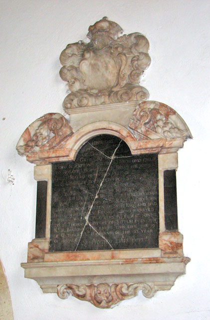
English: The Church of St Leonard in Billingford, Norfolk, mural monument to Christopher Le Grys (1578-1601). Now very worn, heraldry worn away. Recorded by Edmund Farrer, The Church heraldry of Norfolk, Vol.1, 1887[1]: Christopher Le Grys sometime Lord and Patron of this Church, who married Margaret daughter and heir to Thomas Whipple of Dickleburgh and Elizabeth his wife, daughter and coheir to John Garningham of Belton in Suffolk. He died October 19th, 1601, in the 23rd year of his age." Arms: On a bend three boars passant (Le Grys, Quarterly, azure and gules, on a bend argent three boars passant sable. — Bl. Nor/, i. 199 (Francis Blomefield, An essay towards a topographical history of the county of Norfolk, Vol.I, p.199[2]) ; impaling, Quarterly, 1 and 4, A fesse ermine between two chevrons ( Whipple, Azure, a fesse ermine between two chevrons argent. — Bl. Norf. i. 199) ; 2 and 3, Three lozenge buckles (Jernegan or Gerningham, Argent, three lozenge buckles gules.) Crest : A boar passant (Le Grys, A boar passant sable, collared or.)
St Leonard's church > 1769271 is situated on a hill above the busy A143 road, surrounded by fields and adjoined by the Hall. Hall Farm is a little further to the north with its access road, which also serves as a public footpath, leading past the churchyard. The church has a curiously short tower and it is not known if the top has collapsed at some time or whether the tower was never finished. The nave north windows date from the 13th century. The baptismal font > 1769329 is original and has a cover dating from the 16th century. The font cover is contemporary with the fine Jacobean pulpit > 1769302. The pews were remade during a restoration in Victorian time but they retain the original medieval pew ends, some of them with carved faces > 1769305. The rood screen > 1769288 is original also but most of the paint has at some time been removed from the panels. The remains of a 13th century wallpainting > 1769321 can be seen on the south wall. Some of the windows contain fragments of medieval glass > 1769318 dating from the 14th century. |
| Date | |
| Source | From geograph.org.uk |
| Author | Evelyn Simak |
| Attribution (required by the license) | Evelyn Simak / The church of St Leonard in Billingford - wall memorial / |
| Camera location | | View this and other nearby images on: OpenStreetMap |
|---|
_heading:315.00&language=en)
| Object location | | View this and other nearby images on: OpenStreetMap |
|---|
_heading:315.00&language=en)
Licensing
[edit]

|
This image was taken from the Geograph project collection. See this photograph's page on the Geograph website for the photographer's contact details. The copyright on this image is owned by Evelyn Simak and is licensed for reuse under the Creative Commons Attribution-ShareAlike 2.0 license.
|
This file is licensed under the Creative Commons Attribution-Share Alike 2.0 Generic license.
Attribution: Evelyn Simak
- You are free:
- to share – to copy, distribute and transmit the work
- to remix – to adapt the work
- Under the following conditions:
- attribution – You must give appropriate credit, provide a link to the license, and indicate if changes were made. You may do so in any reasonable manner, but not in any way that suggests the licensor endorses you or your use.
- share alike – If you remix, transform, or build upon the material, you must distribute your contributions under the same or compatible license as the original.
File history
Click on a date/time to view the file as it appeared at that time.
| Date/Time | Thumbnail | Dimensions | User | Comment | |
|---|---|---|---|---|---|
| current | 22:04, 11 March 2011 | | 421 × 640 (87 KB) | GeographBot (talk | contribs) | == {{int:filedesc}} == {{Information |description={{en|1=The church of St Leonard in Billingford - wall memorial St Leonard's church > http://www.geograph.org.uk/photo/1769271 is situated on a hill above the busy A143 road, surrounded by fields and adjoin |
You cannot overwrite this file.
File usage on Commons
There are no pages that use this file.