File:The Wylam Wagonway - geograph.org.uk - 1558247.jpg
Jump to navigation
Jump to search
No higher resolution available.
The_Wylam_Wagonway_-_geograph.org.uk_-_1558247.jpg (640 × 480 pixels, file size: 167 KB, MIME type: image/jpeg)
Captions
Captions
Add a one-line explanation of what this file represents
Summary
[edit]
| Description |
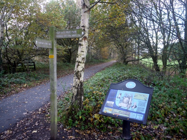
English: The Wylam Wagonway. At one time this was the route of the road between Newcastle and Hexham, preceding both the Military Road and the A69. A waggonway linking Wylam colliery with the coal staithes at Lemington was built alongside it before 1763, one of the earliest on Tyneside. Wagons were drawn by horses along wooden rails.
Iron rails and two steam locomotives made by William Hedley, Wylam Dilly and Puffing Billy 1123205 were in use by 1815. George Stephenson was born by the waggonway 5428 and went on to develop further locomotives that were to revolutionise railways for passenger transport. The waggonway is now part of Hadrian's Way path, which turns right at this signpost, and a national cycle route. |
| Date | |
| Source | From geograph.org.uk |
| Author | Andrew Curtis |
| Attribution (required by the license) | Andrew Curtis / The Wylam Wagonway / |
| Camera location | | View this and other nearby images on: OpenStreetMap |
|---|
_heading:247.00&language=en)
| Object location | | View this and other nearby images on: OpenStreetMap |
|---|
_heading:247.00&language=en)
Licensing
[edit]

|
This image was taken from the Geograph project collection. See this photograph's page on the Geograph website for the photographer's contact details. The copyright on this image is owned by Andrew Curtis and is licensed for reuse under the Creative Commons Attribution-ShareAlike 2.0 license.
|
This file is licensed under the Creative Commons Attribution-Share Alike 2.0 Generic license.
Attribution: Andrew Curtis
- You are free:
- to share – to copy, distribute and transmit the work
- to remix – to adapt the work
- Under the following conditions:
- attribution – You must give appropriate credit, provide a link to the license, and indicate if changes were made. You may do so in any reasonable manner, but not in any way that suggests the licensor endorses you or your use.
- share alike – If you remix, transform, or build upon the material, you must distribute your contributions under the same or compatible license as the original.
File history
Click on a date/time to view the file as it appeared at that time.
| Date/Time | Thumbnail | Dimensions | User | Comment | |
|---|---|---|---|---|---|
| current | 14:46, 3 March 2011 | | 640 × 480 (167 KB) | GeographBot (talk | contribs) | == {{int:filedesc}} == {{Information |description={{en|1=The Wylam Wagonway At one time this was the route of the road between Newcastle and Hexham, preceding both the Military Road and the A69. A waggonway linking Wylam colliery with the coal staithes at |
You cannot overwrite this file.
File usage on Commons
There are no pages that use this file.