File:The White House, Corporation Street, and Whitehouse Bridges - geograph.org.uk - 1455863.jpg
The_White_House,_Corporation_Street,_and_Whitehouse_Bridges_-_geograph.org.uk_-_1455863.jpg (640 × 443 pixels, file size: 67 KB, MIME type: image/jpeg)
Captions
Captions
Summary
[edit]
| Description |
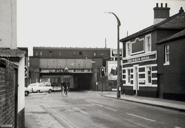
English: The White House, Corporation Street, and Whitehouse Bridges. The White House, on the right in this view, was a public house, with accommodation. It was built in 1841 by Rowdens of Highworth, Wiltshire, on the corner of Corporation Street and Station Road. Originally it was called the Queens Arms Inn. In later decades, up to the end of its life, it was called The White House. Being near the town's main railway station (Swindon used to have two), it was popular with rail travellers in its earlier years. During its last years, however, as the area declined, the pub had rather a mixed reputation. It eventually closed and then later it was demolished in December 2002. Today the site is occupied by flats.
Straight ahead are what were known as Whitehouse Bridges. These were a series of railway bridges carrying various railway lines across Corporation Street. Today only the one in the foreground survives. Because the headroom was only 10 foot 3 inches, literally hundreds of vehicles have got stuck under them. Mainly lorries and double deck buses. This situation continues today, despite every sort of notice and warning having been used to try and stop people driving tall vehicles on this route. View from the other end:- 1480143. A technical note - this picture has been submitted because of its historic interest. Unfortunately the quality is poor because it had to be scanned, of necessity, from a small print. In turn this originated from a tiny 13mm x 17mm negative, taken on a 110 size cartridge film camera, and using Kodak's rather grainy Verichrome Pan film! |
| Date | |
| Source | From geograph.org.uk |
| Author | P L Chadwick |
| Attribution (required by the license) | P L Chadwick / The White House, Corporation Street, and Whitehouse Bridges / |
| Camera location | | View this and other nearby images on: OpenStreetMap |
|---|
_heading:337.00&language=en)
| Object location | | View this and other nearby images on: OpenStreetMap |
|---|
_heading:337.00&language=en)
Licensing
[edit]

|
This image was taken from the Geograph project collection. See this photograph's page on the Geograph website for the photographer's contact details. The copyright on this image is owned by P L Chadwick and is licensed for reuse under the Creative Commons Attribution-ShareAlike 2.0 license.
|
- You are free:
- to share – to copy, distribute and transmit the work
- to remix – to adapt the work
- Under the following conditions:
- attribution – You must give appropriate credit, provide a link to the license, and indicate if changes were made. You may do so in any reasonable manner, but not in any way that suggests the licensor endorses you or your use.
- share alike – If you remix, transform, or build upon the material, you must distribute your contributions under the same or compatible license as the original.
File history
Click on a date/time to view the file as it appeared at that time.
| Date/Time | Thumbnail | Dimensions | User | Comment | |
|---|---|---|---|---|---|
| current | 06:36, 2 March 2011 | | 640 × 443 (67 KB) | GeographBot (talk | contribs) | == {{int:filedesc}} == {{Information |description={{en|1=The White House, Corporation Street, and Whitehouse Bridges The White House, on the right in this view, was a public house, with accommodation. It was built in 1841 by Rowdens of Highworth, Wiltshir |
You cannot overwrite this file.
File usage on Commons
There are no pages that use this file.