File:The Search for Malaysia Airlines Flight 370 (March through October 2014) zh.svg
Jump to navigation
Jump to search

Size of this PNG preview of this SVG file: 686 × 599 pixels. Other resolutions: 275 × 240 pixels | 549 × 480 pixels | 879 × 768 pixels | 1,172 × 1,024 pixels | 2,344 × 2,048 pixels | 5,020 × 4,387 pixels.
Original file (SVG file, nominally 5,020 × 4,387 pixels, file size: 8.53 MB)
Captions
Captions
Add a one-line explanation of what this file represents
Summary
[edit]| Description |
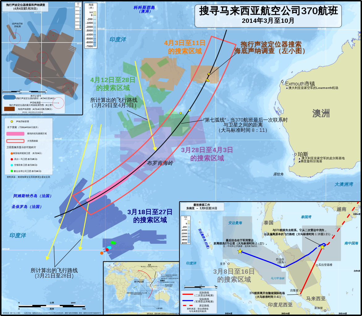
中文(简体):马航370航班从失踪当天直到2014年5月的搜索地图。还有计划中的水下搜索区域于2014年10月头开始搜索,并计划持续长达一年(当然,如果飞机被发现,就停止搜索)。
未显示:
English: Simplified Chinese version of a map of search areas for Malaysia Airlines Flight 370 from the day of its disappearance until May 2014 (See English version). Planned search areas for the underwater phase of the search began in the beginning of October 2014 and is planned to last up to one year (ending, of course, if the plane is found).
Not shown:
|
| Date | /2014年11月9日 |
| Source |
Own work by the original uploader/原创作品来自上传者 Translations (各项翻译). 中文(简体):此地图的数据来自以下各种来源。地点(例如:开展搜索的区域,卫星所探测到的碎片位置和声学检测)是不能受到版权保护的事实资料,虽然大多数的来源已在该地图中展示。
主要地图
拖行声波定位器搜索路径和海底声纳调查地点:
最初搜索区域:
概览插图
背景:
English: The following sources were used for data included in the map. Locations (eg. where the search was conducted, locations of satellite debris & acoustic detections) are factual information which cannot be copyrighted, although most sources are noted in the map.
Main map
Towed Pinger Locator path & seafloor sonar survey location:
Initial search areas:
Overview inset
Backgrounds:
|
| Author |
Original map/原始地图: Andrew Heneen |
| Permission (Reusing this file) |
Andrew Heneen, the copyright holder of this work, hereby publishes it under the following license: This file is licensed under the Creative Commons Attribution-Share Alike 3.0 Unported license. Attribution: Andrew Heneen
|
| Other versions |
|
| SVG development |

_zh.svg&action=edit§ion=1)
File history
Click on a date/time to view the file as it appeared at that time.
| Date/Time | Thumbnail | Dimensions | User | Comment | |
|---|---|---|---|---|---|
| current | 13:30, 12 August 2015 | | 5,020 × 4,387 (8.53 MB) | Storkk (talk | contribs) | corrections per Special:Diff/168320981/168323983 |
| 16:58, 11 August 2015 |  | 5,020 × 4,387 (8.53 MB) | Storkk (talk | contribs) | corrections per Special:Diff/168277718 | |
| 10:55, 11 August 2015 |  | 5,020 × 4,387 (8.53 MB) | Storkk (talk | contribs) | =={{int:filedesc}}== {{Information |description={{en|1=Simplified Chinese version of a map of search areas for Malaysia Airlines Flight 370 from the day of its disappearance through May 2014 and the planned search areas for the underwater phase of the... |
You cannot overwrite this file.
File usage on Commons
The following 5 pages use this file:
_zh.svg)
_zh.svg&oldid=523774419)