File:The Road to Dushanbe (NESDIS 2017-10-26).png
Jump to navigation
Jump to search

Size of this preview: 800 × 450 pixels. Other resolutions: 320 × 180 pixels | 640 × 360 pixels | 1,024 × 576 pixels | 1,280 × 720 pixels | 1,920 × 1,080 pixels.
Original file (1,920 × 1,080 pixels, file size: 1.38 MB, MIME type: image/png)
Captions
Captions
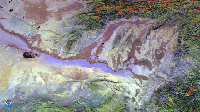
A cloud-free day reveals some of the dynamic geography in a relatively remote area of the world along the borders of Afghanistan, Tajikistan, Uzbekistan and Turkmenistan.
Summary
[edit].png&action=edit§ion=1)
| Description |
English: A cloud-free day reveals some of the dynamic geography in a relatively remote area of the world along the borders of Afghanistan, Tajikistan, Uzbekistan and Turkmenistan. Using the VIIRS SVI 2, 3, and 4 channels from the Suomi NPP Satellite on October 26, 2017, this RGB false-color image shows visible and thermal differences in the desert, high altitude and riverbed areas in the region. |
| Date | 26 October 2017 (upload date) |
| Source | The Road to Dushanbe |
| Author | NOAA |
Licensing
[edit].png&action=edit§ion=2)
This image is in the public domain because it contains materials that originally came from the U.S. National Oceanic and Atmospheric Administration, taken or made as part of an employee's official duties.
|
File history
Click on a date/time to view the file as it appeared at that time.
| Date/Time | Thumbnail | Dimensions | User | Comment | |
|---|---|---|---|---|---|
| current | 15:58, 2 June 2024 | | 1,920 × 1,080 (1.38 MB) | OptimusPrimeBot (talk | contribs) | #Spacemedia - Upload of https://nesdis-prod.s3.amazonaws.com/2021-07/2126v1_20172016-Eurasia-VIIRS234.png via Commons:Spacemedia |
You cannot overwrite this file.
File usage on Commons
There are no pages that use this file.
.png&oldid=880927720)