File:The Railway Station at Grange-over-Sands - geograph.org.uk - 1517637.jpg
Jump to navigation
Jump to search
No higher resolution available.
The_Railway_Station_at_Grange-over-Sands_-_geograph.org.uk_-_1517637.jpg (640 × 480 pixels, file size: 81 KB, MIME type: image/jpeg)
Captions
Captions
Add a one-line explanation of what this file represents
Summary
[edit]
| Description |
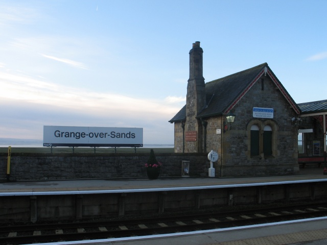
English: The Railway Station at Grange-over-Sands Grange-over-Sands is a small Cumbrian seaside town lying on the north side of Morecambe Bay. Originally a small fishing village, Grange developed during the second half of the 19th Century with the arrival of the Lancaster & Ulverston Railway (later absorbed into the Furness Railway), when it became a popular seaside resort and much of this is evident in the Town's (mostly unspoiled) Victorian architecture.
An early morning view of Grange-over-Sands Station looking towards Morcambe Bay. The Ulverstone & Lancaster Railway was opened through the first station on this site on 27th August 1857: the first passenger train ran on 1st September. The Furness Railway, having absorbed the U&LR in 1862, commissioned the architect Edward Graham Paley of Lancaster to design the present station, which was built in 1864-72. The station is listed Grade II and stands in a Conservation Area. It was restored in 1997/98. |
| Date | |
| Source | From geograph.org.uk |
| Author | Ian Petticrew |
| Camera location | | View this and other nearby images on: OpenStreetMap |
|---|
_heading:135.00&language=en)
| Object location | | View this and other nearby images on: OpenStreetMap |
|---|
_heading:135.00&language=en)
Licensing
[edit]

|
This image was taken from the Geograph project collection. See this photograph's page on the Geograph website for the photographer's contact details. The copyright on this image is owned by Ian Petticrew and is licensed for reuse under the Creative Commons Attribution-ShareAlike 2.0 license.
|
This file is licensed under the Creative Commons Attribution-Share Alike 2.0 Generic license.
Attribution: Ian Petticrew
- You are free:
- to share – to copy, distribute and transmit the work
- to remix – to adapt the work
- Under the following conditions:
- attribution – You must give appropriate credit, provide a link to the license, and indicate if changes were made. You may do so in any reasonable manner, but not in any way that suggests the licensor endorses you or your use.
- share alike – If you remix, transform, or build upon the material, you must distribute your contributions under the same or compatible license as the original.
File history
Click on a date/time to view the file as it appeared at that time.
| Date/Time | Thumbnail | Dimensions | User | Comment | |
|---|---|---|---|---|---|
| current | 01:18, 3 March 2011 | | 640 × 480 (81 KB) | GeographBot (talk | contribs) | == {{int:filedesc}} == {{Information |description={{en|1=The Railway Station at Grange-over-Sands Grange-over-Sands is a small Cumbrian seaside town lying on the north side of Morecambe Bay. Originally a small fishing village, Grange developed during the |
You cannot overwrite this file.
File usage on Commons
There are no pages that use this file.