File:The Quarterly journal of the Geological Society of London (12895041495).jpg

Original file (1,226 × 2,061 pixels, file size: 518 KB, MIME type: image/jpeg)
Captions
Captions
Summary
[edit]| Description |
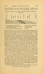
1864..
but
not
in
such
great
quantities.
These
and
Quart. Journ. Geol. Soc. vol. xix. p. 522. |
||
| Date | |||
| Source | https://www.flickr.com/photos/biodivlibrary/12895041495 | ||
| Author | Geological Society of London | ||
| Full title | The Quarterly journal of the Geological Society of London. | ||
| Page ID | 36089708 | ||
| Item ID | 111261 (Find related Wikimedia Commons images) | ||
| Title ID | 51125 | ||
| Page numbers | Page 439 | ||
| Names | NameFound:Coccosteus NameConfirmed:Coccosteus EOLID:4655829 NameBankID:4120354 NameFound:Osteolepis NameConfirmed:Osteolepis EOLID:13230688 NameBankID:4271975 | ||
| BHL Page URL | https://www.biodiversitylibrary.org/page/36089708 | ||
| Page type | Text | ||
| Flickr sets |
|
||
| Flickr tags |
|
||
| Flickr posted date | 3 March 2014 | ||
| Credit |
|

.jpg&action=edit§ion=1)

|
The categories of this image need checking. You can do so here.
|
.jpg&action=edit&withJS=MediaWiki:Catcheck.js)
Licensing
[edit].jpg&action=edit§ion=2)
- You are free:
- to share – to copy, distribute and transmit the work
- to remix – to adapt the work
- Under the following conditions:
- attribution – You must give appropriate credit, provide a link to the license, and indicate if changes were made. You may do so in any reasonable manner, but not in any way that suggests the licensor endorses you or your use.
| This image was originally posted to Flickr by BioDivLibrary at https://flickr.com/photos/61021753@N02/12895041495. It was reviewed on 26 August 2015 by FlickreviewR and was confirmed to be licensed under the terms of the cc-by-2.0. |
This image is in the public domain because it is a mere mechanical scan or photocopy of a public domain original, or – from the available evidence – is so similar to such a scan or photocopy that no copyright protection can be expected to arise. The original itself is in the public domain for the following reason:
This tag is designed for use where there may be a need to assert that any enhancements (eg brightness, contrast, colour-matching, sharpening) are in themselves insufficiently creative to generate a new copyright. It can be used where it is unknown whether any enhancements have been made, as well as when the enhancements are clear but insufficient. For known raw unenhanced scans you can use an appropriate {{PD-old}} tag instead. For usage, see Commons:When to use the PD-scan tag.  | ||||
File history
Click on a date/time to view the file as it appeared at that time.
| Date/Time | Thumbnail | Dimensions | User | Comment | |
|---|---|---|---|---|---|
| current | 16:02, 26 August 2015 | | 1,226 × 2,061 (518 KB) | Fæ (talk | contribs) | == {{int:filedesc}} == {{BHL | title = The Quarterly journal of the Geological Society of London. | source = http://www.flickr.com/photos/biodivlibrary/12895041495 | description = 1864.. <br> BARENESS NORTU-EAST OF SCOTLAND. <br> 439 <br> form o... |
You cannot overwrite this file.
File usage on Commons
There are no pages that use this file.
.jpg&oldid=896030853)