File:The Origin of Anyang (Unified Silla Kingdom - Goryeo Dynasty).jpg
Jump to navigation
Jump to search

Size of this preview: 800 × 600 pixels. Other resolutions: 320 × 240 pixels | 640 × 480 pixels | 1,024 × 768 pixels | 1,280 × 960 pixels | 2,560 × 1,920 pixels | 9,248 × 6,936 pixels.
Original file (9,248 × 6,936 pixels, file size: 11.3 MB, MIME type: image/jpeg)
Captions
Captions
Wang Geon met Buddhist monk named Neungjeong at the Mt. Samseong and built the Anyang Temple (Anyangsa) in 900 A.D.
Summary
[edit].jpg&action=edit§ion=1)
| Description |
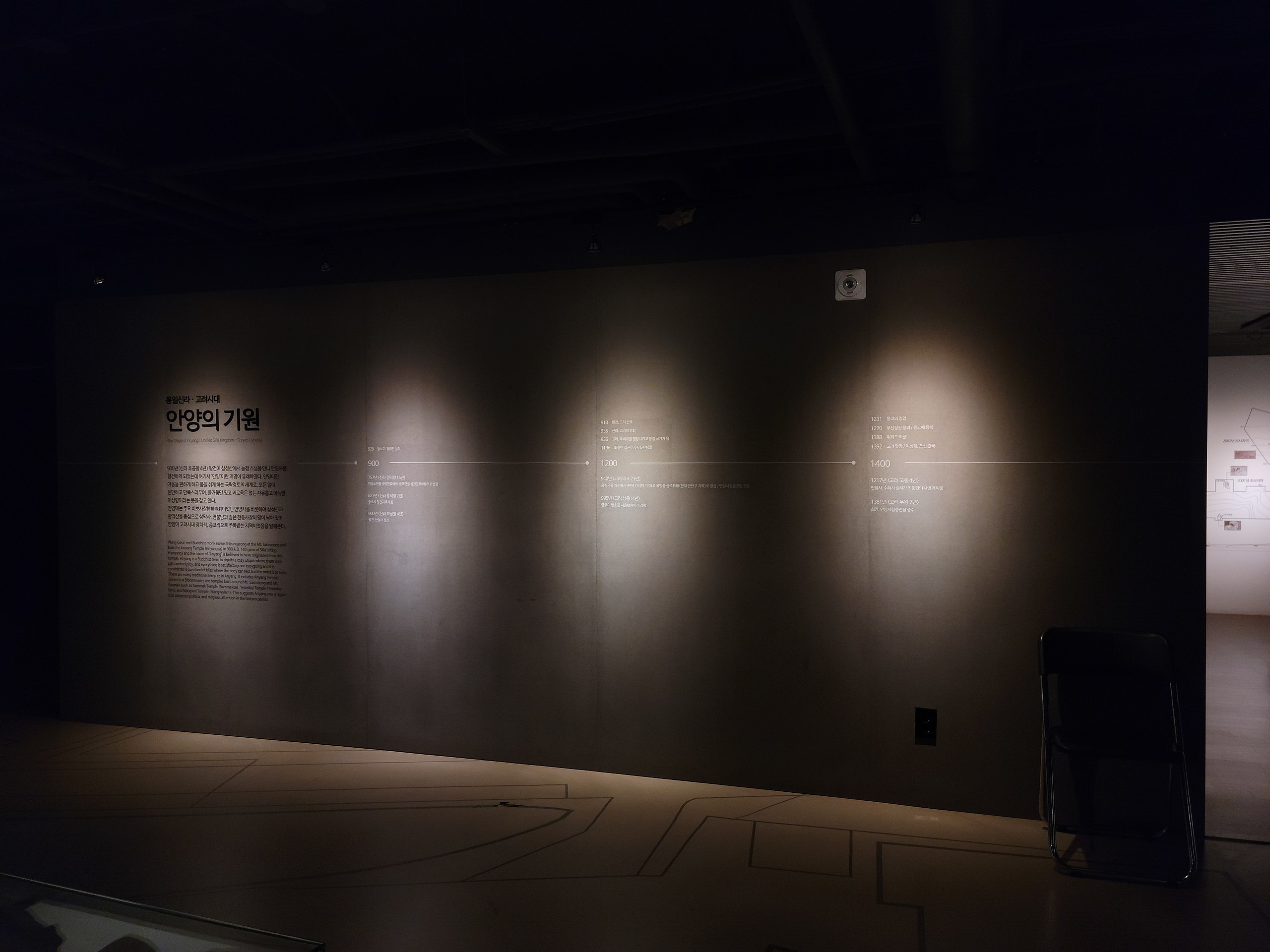
한국어: 900년(신라 효공왕 4년) 왕건이 삼성산에서 능정 스님을 만나 안양사를 창건하게 되었는데 여기서 '안양'이란 지명이 유래하였다. 안양이란 마음을 편하게 하고 몸을 쉬어가는 극락정토의 세계로, 모든 일이 원만하고 만족스러우며, 즐거움만 있고 괴로움은 없는 자유롭고 아늑한 이상향이라는 뜻을 갖고 있다. 안양에는 주요 비보사찰(裨補寺刹)이었던 안양사를 비롯하여 삼성산과 관악산을 중심으로 삼막사, 염불암과 같은 전통사찰이 많이 남아있어 안양이 고려시대 정치적, 종교적으로 주목받는 지역이었음을 말해준다.
English: Wang Geon met Buddhist monk named Neungjeong at the Mt. Samseong and built the Anyang Temple (Anyangsa) in 900 A.D. (4th year of Silla's king Hyogong) and the name of Anyang is believed to have originated form this temple. Anyang us a Buddhist term to signify a cozy utopia wher there is no pain and only joy, and everthing is satisfactory and easygoing and it is considered a pure land of bliss where the body can rest and the mind is at ease. There are many Traditional temp es in Anyang. It includes Anyang Temple(which is a Biboitemple) and temples built around Mt. Samseong and Mt. Gwanak such as Sammak Temple (Sammaksa), Teombyl Temple (Teombu-lam), and Mangwol Temple (Mangwolam). This suggests Anyang was a region that attracted politica and religious attention in the Goryeo period. |
| Date | |
| Source | Own work |
| Author | 고려 |
| Camera location | | View this and other nearby images on: OpenStreetMap |
|---|
.jpg¶ms=037.418420_N_0126.918439_E_globe:Earth_type:camera__&language=en)
Licensing
[edit].jpg&action=edit§ion=2)
I, the copyright holder of this work, hereby publish it under the following license:
This file is licensed under the Creative Commons Attribution 4.0 International license.
- You are free:
- to share – to copy, distribute and transmit the work
- to remix – to adapt the work
- Under the following conditions:
- attribution – You must give appropriate credit, provide a link to the license, and indicate if changes were made. You may do so in any reasonable manner, but not in any way that suggests the licensor endorses you or your use.
File history
Click on a date/time to view the file as it appeared at that time.
| Date/Time | Thumbnail | Dimensions | User | Comment | |
|---|---|---|---|---|---|
| current | 16:19, 13 December 2020 | | 9,248 × 6,936 (11.3 MB) | 고려 (talk | contribs) | Uploaded own work with UploadWizard |
You cannot overwrite this file.
File usage on Commons
There are no pages that use this file.
.jpg&oldid=735008622)