File:The Olde Mint, Southam, geograph 5025968 by Dylan Moore.jpg
From Wikimedia Commons, the free media repository
Jump to navigation
Jump to search
![File:The Olde Mint, Southam, geograph 5025968 by Dylan Moore.jpg](https://upload.wikimedia.org/wikipedia/commons/thumb/e/ef/The_Olde_Mint%2C_Southam%2C_geograph_5025968_by_Dylan_Moore.jpg/800px-The_Olde_Mint%2C_Southam%2C_geograph_5025968_by_Dylan_Moore.jpg?20200810183317)
Size of this preview: 800 × 590 pixels. Other resolutions: 320 × 236 pixels | 640 × 472 pixels | 1,024 × 755 pixels | 1,280 × 944 pixels | 2,560 × 1,887 pixels.
Original file (2,560 × 1,887 pixels, file size: 2.81 MB, MIME type: image/jpeg)
File information
Structured data
Captions
Captions
Add a one-line explanation of what this file represents
Summary
[edit]DescriptionThe Olde Mint, Southam, geograph 5025968 by Dylan Moore.jpg |
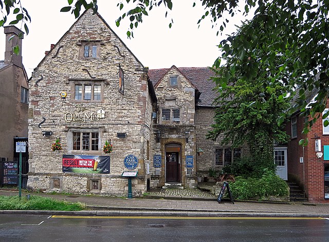
English: The Olde Mint, Southam
Early sixteenth century house constructed with the same materials as the parish church: white Lias limestone, and details in red Bunter sandstone. Alleged to have been used as a mint during the Civil War. |
||
Date | |||
Source | geograph.org.uk | ||
Author | Dylan Moore | ||
Permission (Reusing this file) |
![]() ![]() ![]() This file is licensed under the Creative Commons Attribution-Share Alike 2.0 Generic license. Attribution: Dylan Moore
|
||
Attribution (required by the license) InfoField | Dylan Moore / The Olde Mint, Southam / | ||
InfoField | Dylan Moore / The Olde Mint, Southam |
Camera location | 52° 15′ 14.09″ N, 1° 23′ 16.2″ W ![]() ![]() | View this and other nearby images on: OpenStreetMap | ![]() |
---|
Object location | 52° 15′ 14.12″ N, 1° 23′ 14.9″ W ![]() ![]() | View this and other nearby images on: OpenStreetMap | ![]() |
---|
File history
Click on a date/time to view the file as it appeared at that time.
Date/Time | Thumbnail | Dimensions | User | Comment | |
---|---|---|---|---|---|
current | 18:33, 10 August 2020 | ![]() | 2,560 × 1,887 (2.81 MB) | G-13114 (talk | contribs) | == {{int:filedesc}} == {{Information |description={{en|1=The Olde Mint, Southam Early sixteenth century house constructed with the same materials as the parish church: white Lias limestone, and details in red Bunter sandstone. Alleged to have been used as a mint during the Civil War.}} |date=2016-06-28 |source= [https://www.geograph.org.uk geograph.org.uk] |author= Dylan Moore |permission= {{Geograph|5025968|Dylan Moore}} |other_versions= |other fields= {{Credit line |Author = Dylan Moor... |
You cannot overwrite this file.
File usage on Commons
There are no pages that use this file.
File usage on other wikis
The following other wikis use this file:
- Usage on en.wikipedia.org
Metadata
This file contains additional information such as Exif metadata which may have been added by the digital camera, scanner, or software program used to create or digitize it. If the file has been modified from its original state, some details such as the timestamp may not fully reflect those of the original file. The timestamp is only as accurate as the clock in the camera, and it may be completely wrong.
Camera manufacturer | Canon |
---|---|
Camera model | Canon IXUS 255 HS |
Exposure time | 1/40 sec (0.025) |
F-number | f/3.2 |
ISO speed rating | 125 |
Date and time of data generation | 17:33, 28 June 2016 |
Lens focal length | 5.865 mm |
Orientation | Normal |
Horizontal resolution | 180 dpi |
Vertical resolution | 180 dpi |
Software used | Adobe Photoshop Elements 7.0 Windows |
File change date and time | 21:22, 6 July 2016 |
Y and C positioning | Co-sited |
Exif version | 2.3 |
Date and time of digitizing | 17:33, 28 June 2016 |
Meaning of each component |
|
Image compression mode | 3 |
APEX shutter speed | 5.3125 |
APEX aperture | 3.34375 |
APEX exposure bias | 0 |
Maximum land aperture | 3.34375 APEX (f/3.19) |
Metering mode | Pattern |
Flash | Flash did not fire, compulsory flash suppression |
Supported Flashpix version | 1 |
Color space | sRGB |
Focal plane X resolution | 16,393.442622951 |
Focal plane Y resolution | 16,393.442622951 |
Focal plane resolution unit | inches |
Sensing method | One-chip color area sensor |
File source | Digital still camera |
Custom image processing | Normal process |
Exposure mode | Auto exposure |
White balance | Auto white balance |
Digital zoom ratio | 1 |
Scene capture type | Standard |
GPS tag version | 0.0.3.2 |
Supported Flashpix version | 1 |
Image width | 2,560 px |
Image height | 1,887 px |
Rating (out of 5) | 0 |
Date metadata was last modified | 22:22, 6 July 2016 |
IIM version | 31,839 |
Structured data
Items portrayed in this file
depicts
28 June 2016
52°15'14.094"N, 1°23'16.152"W
52°15'14.123"N, 1°23'14.856"W
0.025 second
3.2
5.865 millimetre
125
image/jpeg
Hidden categories:
- CC-BY-SA-2.0
- Images from Geograph Britain and Ireland
- Images from Geograph Britain and Ireland missing SDC creator
- Images from Geograph Britain and Ireland missing SDC source of file
- Information field template with formatting
- Files with coordinates missing SDC location of creation (52° N, 2° W)
- Pages with maps