File:The Old Swing Bridge Reeth - geograph.org.uk - 339765.jpg
Jump to navigation
Jump to search
No higher resolution available.
The_Old_Swing_Bridge_Reeth_-_geograph.org.uk_-_339765.jpg (640 × 447 pixels, file size: 78 KB, MIME type: image/jpeg)
Captions
Captions
Add a one-line explanation of what this file represents
Summary
[edit]
| Description |
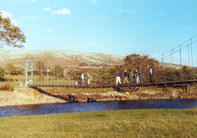
English: The Old Swing Bridge Reeth A photo of the original 1920 suspension bridge [locally known as the 'swing bridge']before its destruction by a large tree trunk carried down by a flood on 19th September 2000. Compare this 1990 picture with the one of the current bridge, which is a near perfect copy of the old one. The replacement of the bridge took much longer than anticipated, as the original was built through public subscription, and thus there was no legal owner of the structure - and no right of way across it. Eventually several different authorities and agencies helped towards the cost of the new bridge and a new prow footpath was established to link the north and south bank. It is interesting to see the wooden piles and boarding on the opposite bank, as these have long since disappeared through further erosion. |
| Date | |
| Source | From geograph.org.uk |
| Author | Gordon Hatton |
| Attribution (required by the license) | Gordon Hatton / The Old Swing Bridge Reeth / |
| Object location | | View this and other nearby images on: OpenStreetMap |
|---|
_heading:45.00&language=en)
Licensing
[edit]

|
This image was taken from the Geograph project collection. See this photograph's page on the Geograph website for the photographer's contact details. The copyright on this image is owned by Gordon Hatton and is licensed for reuse under the Creative Commons Attribution-ShareAlike 2.0 license.
|
This file is licensed under the Creative Commons Attribution-Share Alike 2.0 Generic license.
Attribution: Gordon Hatton
- You are free:
- to share – to copy, distribute and transmit the work
- to remix – to adapt the work
- Under the following conditions:
- attribution – You must give appropriate credit, provide a link to the license, and indicate if changes were made. You may do so in any reasonable manner, but not in any way that suggests the licensor endorses you or your use.
- share alike – If you remix, transform, or build upon the material, you must distribute your contributions under the same or compatible license as the original.
File history
Click on a date/time to view the file as it appeared at that time.
| Date/Time | Thumbnail | Dimensions | User | Comment | |
|---|---|---|---|---|---|
| current | 22:41, 30 December 2010 | | 640 × 447 (78 KB) | GeographBot (talk | contribs) | == {{int:filedesc}} == {{Information |description={{en|1=The Old Swing Bridge Reeth A photo of the original 1920 suspension bridge [locally known as the 'swing bridge']before its destruction by a large tree trunk carried down by a flood on 19th September |
You cannot overwrite this file.
File usage on Commons
There are no pages that use this file.