File:The Monument to the Air Defence of Swansea 1939-1945 - geograph.org.uk - 498182.jpg
Jump to navigation
Jump to search
No higher resolution available.
The_Monument_to_the_Air_Defence_of_Swansea_1939-1945_-_geograph.org.uk_-_498182.jpg (640 × 480 pixels, file size: 59 KB, MIME type: image/jpeg)
Captions
Captions
Add a one-line explanation of what this file represents
Summary
[edit]
| Description |
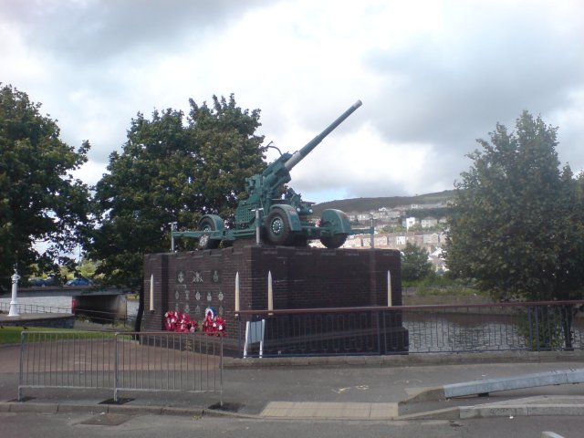
English: The Monument to the Air Defence of Swansea 1939-1945 The monument commemorates the valiant work performed by Swansea's anti-aircraft batteries and also serves as a reminder to the horrific destruction that occurred in the town of Swansea during the Second World War, especially on the night of 21st February 1941 when Swansea was specifically targeted by many hundreds of German planes.
It's a well known fact that the gun batteries were able to bring down very few planes, mainly due to the ferocity of the attacks and because the technology simply wasn't able to pinpoint aircraft then. |
| Date | |
| Source | From geograph.org.uk |
| Author | Hywel Williams |
| Attribution (required by the license) | Hywel Williams / The Monument to the Air Defence of Swansea 1939-1945 / |
| Camera location | | View this and other nearby images on: OpenStreetMap |
|---|
_heading:67.00&language=en)
| Object location | | View this and other nearby images on: OpenStreetMap |
|---|
_heading:67.00&language=en)
Licensing
[edit]

|
This image was taken from the Geograph project collection. See this photograph's page on the Geograph website for the photographer's contact details. The copyright on this image is owned by Hywel Williams and is licensed for reuse under the Creative Commons Attribution-ShareAlike 2.0 license.
|
This file is licensed under the Creative Commons Attribution-Share Alike 2.0 Generic license.
Attribution: Hywel Williams
- You are free:
- to share – to copy, distribute and transmit the work
- to remix – to adapt the work
- Under the following conditions:
- attribution – You must give appropriate credit, provide a link to the license, and indicate if changes were made. You may do so in any reasonable manner, but not in any way that suggests the licensor endorses you or your use.
- share alike – If you remix, transform, or build upon the material, you must distribute your contributions under the same or compatible license as the original.
File history
Click on a date/time to view the file as it appeared at that time.
| Date/Time | Thumbnail | Dimensions | User | Comment | |
|---|---|---|---|---|---|
| current | 06:18, 5 February 2011 | | 640 × 480 (59 KB) | GeographBot (talk | contribs) | == {{int:filedesc}} == {{Information |description={{en|1=The Monument to the Air Defence of Swansea 1939-1945 The monument commemorates the valiant work performed by Swansea's anti-aircraft batteries and also serves as a reminder to the horrific destructi |
You cannot overwrite this file.
File usage on Commons
There are no pages that use this file.
File usage on other wikis
The following other wikis use this file: