File:The Manger on a Summer's Evening - geograph.org.uk - 26011.jpg
Jump to navigation
Jump to search
No higher resolution available.
The_Manger_on_a_Summer's_Evening_-_geograph.org.uk_-_26011.jpg (640 × 480 pixels, file size: 409 KB, MIME type: image/jpeg)
Captions
Captions
Add a one-line explanation of what this file represents
Summary
[edit]
| Description |
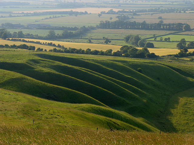
English: The Manger on a Summer's Evening. This square is of historical and geographical value and the land managed by the national trust. The square contains this interesting hill structure and is the western part of "The Manger", Dragon Hill being on the eastern side. Uffington Castle fort is contained mostly in this square with about a third of it in the next adjacent square. This view of the manager was taken from the vicinity of the white horse in the adjacent square, looking more or less north west. |
| Date | |
| Source | From geograph.org.uk |
| Author | Pam Brophy |
| Attribution (required by the license) | Pam Brophy / The Manger on a Summer's Evening / |
| Object location | | View this and other nearby images on: OpenStreetMap |
|---|
_&language=en)
Licensing
[edit]

|
This image was taken from the Geograph project collection. See this photograph's page on the Geograph website for the photographer's contact details. The copyright on this image is owned by Pam Brophy and is licensed for reuse under the Creative Commons Attribution-ShareAlike 2.0 license.
|
This file is licensed under the Creative Commons Attribution-Share Alike 2.0 Generic license.
Attribution: Pam Brophy
- You are free:
- to share – to copy, distribute and transmit the work
- to remix – to adapt the work
- Under the following conditions:
- attribution – You must give appropriate credit, provide a link to the license, and indicate if changes were made. You may do so in any reasonable manner, but not in any way that suggests the licensor endorses you or your use.
- share alike – If you remix, transform, or build upon the material, you must distribute your contributions under the same or compatible license as the original.
- Remove redundant categories and try to put this image in the most specific category/categories
- Remove this template
- The location categories are based on information from this geonames tool and this OpenStreetMap tool combined with a database. You can also have a look at this tool from mysociety.
- The topic category from Geograph was Hill (find similar images at Geograph)
File history
Click on a date/time to view the file as it appeared at that time.
| Date/Time | Thumbnail | Dimensions | User | Comment | |
|---|---|---|---|---|---|
| current | 05:25, 30 January 2010 | | 640 × 480 (409 KB) | GeographBot (talk | contribs) | == {{int:filedesc}} == {{Information |description={{en|1=The Manger on a Summer's Evening. This square is of historical and geographical value and the land managed by the national trust. The square contains this interesting hill structure and is the weste |
You cannot overwrite this file.
File usage on Commons
There are no pages that use this file.
File usage on other wikis
The following other wikis use this file:
- Usage on sv.wikipedia.org