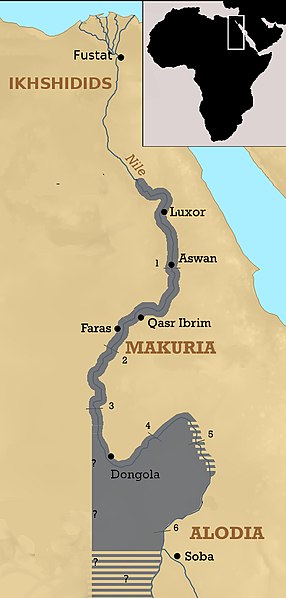
File:The Kingdom of Makuria at its peak.jpg
From Wikimedia Commons, the free media repository
Jump to navigation
Jump to search

Size of this preview: 286 × 598 pixels. Other resolutions: 115 × 240 pixels | 495 × 1,035 pixels.
Original file (495 × 1,035 pixels, file size: 198 KB, MIME type: image/jpeg)
File information
Structured data
Captions
Captions
Add a one-line explanation of what this file represents
Summary
[edit]| DescriptionThe Kingdom of Makuria at its peak.jpg |
English: Under king Zacharias IV, the Nubians managed to advance as far north as Akhmim, benefiting from the weakness of the Ikhshidids. Upper Egpt, or at least parts of it, remained occupied for some time (interpretation derived from Roland Werner's "Das Christentum in Nubien"). It would also have extended far into the south, for Ibn Hawqal, who visited Nubia during the 950's, claims that the kings of Dongola asserted control over a region west of the White Nile. |
| Date | |
| Source | Own work |
| Author | LeGabrie |
| Other versions |
|
Licensing
[edit]I, the copyright holder of this work, hereby publish it under the following license:
This file is licensed under the Creative Commons Attribution-Share Alike 4.0 International license.
- You are free:
- to share – to copy, distribute and transmit the work
- to remix – to adapt the work
- Under the following conditions:
- attribution – You must give appropriate credit, provide a link to the license, and indicate if changes were made. You may do so in any reasonable manner, but not in any way that suggests the licensor endorses you or your use.
- share alike – If you remix, transform, or build upon the material, you must distribute your contributions under the same or compatible license as the original.
File history
Click on a date/time to view the file as it appeared at that time.
| Date/Time | Thumbnail | Dimensions | User | Comment | |
|---|---|---|---|---|---|
| current | 21:49, 24 March 2018 |  | 495 × 1,035 (198 KB) | LeGabrie (talk | contribs) | Added beams in the south |
| 22:22, 16 February 2018 |  | 495 × 1,035 (195 KB) | LeGabrie (talk | contribs) | Brightened the background of the mini map. | |
| 20:27, 16 February 2018 |  | 495 × 1,035 (187 KB) | LeGabrie (talk | contribs) | Included (possible) holdings in central Sudan | |
| 22:33, 11 February 2018 |  | 495 × 1,035 (198 KB) | LeGabrie (talk | contribs) | User created page with UploadWizard |
You cannot overwrite this file.
File usage on Commons
The following page uses this file:
File usage on other wikis
The following other wikis use this file:
- Usage on ar.wikipedia.org
- Usage on cs.wikipedia.org
- Usage on en.wikipedia.org
- Usage on hu.wikipedia.org
- Usage on id.wikipedia.org
- Usage on ko.wikipedia.org
- Usage on mk.wikipedia.org
- Usage on ru.wikipedia.org
- Usage on ta.wikipedia.org
- Usage on tr.wikipedia.org
- Usage on vi.wikipedia.org
- Usage on zh.wikipedia.org
Hidden categories:
