File:The Humber Bridge from Paull - geograph.org.uk - 342039.jpg
Jump to navigation
Jump to search
No higher resolution available.
The_Humber_Bridge_from_Paull_-_geograph.org.uk_-_342039.jpg (640 × 480 pixels, file size: 80 KB, MIME type: image/jpeg)
Captions
Captions
Add a one-line explanation of what this file represents
Summary
[edit]
| Description |
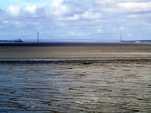
English: The Humber Bridge from Paull, East Riding of Yorkshire, England. Taken with a telephoto lens, the bridge is 8.9 miles (14.3Km) away at this point! The south tower is on the left and in the River Humber itself, whereas the north tower is situated on dry land at Hessle Foreshore. The lead up span on the south side is longer than its equivalent north one. To compensate for this, the north lead up cables have more strands than their southern counterparts as their angle is steeper (do you remember your 'triangle of forces' from O-Level Physics!?). |
| Date | |
| Source | From geograph.org.uk |
| Author | Andy Beecroft |
| Permission (Reusing this file) |
Creative Commons Attribution Share-alike license 2.0 |
| Attribution (required by the license) | Andy Beecroft / The Humber Bridge from Paull / |
| Object location | | View this and other nearby images on: OpenStreetMap |
|---|
_heading:270.00&language=en)
Licensing
[edit]

|
This image was taken from the Geograph project collection. See this photograph's page on the Geograph website for the photographer's contact details. The copyright on this image is owned by Andy Beecroft and is licensed for reuse under the Creative Commons Attribution-ShareAlike 2.0 license.
|
This file is licensed under the Creative Commons Attribution-Share Alike 2.0 Generic license.
Attribution: Andy Beecroft
- You are free:
- to share – to copy, distribute and transmit the work
- to remix – to adapt the work
- Under the following conditions:
- attribution – You must give appropriate credit, provide a link to the license, and indicate if changes were made. You may do so in any reasonable manner, but not in any way that suggests the licensor endorses you or your use.
- share alike – If you remix, transform, or build upon the material, you must distribute your contributions under the same or compatible license as the original.
File history
Click on a date/time to view the file as it appeared at that time.
| Date/Time | Thumbnail | Dimensions | User | Comment | |
|---|---|---|---|---|---|
| current | 18:05, 2 January 2011 | | 640 × 480 (80 KB) | GeographBot (talk | contribs) | == {{int:filedesc}} == {{Information |description={{en|1=The Humber Bridge from Paull Taken with a telephoto lens, the bridge is 8.9 miles (14.3Km) away at this point! The south tower is on the left and in the River Humber itslef, whereas the north tower |
You cannot overwrite this file.
File usage on Commons
There are no pages that use this file.