File:The Hull to Withernsea Railway - geograph.org.uk - 234894.jpg
Jump to navigation
Jump to search
No higher resolution available.
The_Hull_to_Withernsea_Railway_-_geograph.org.uk_-_234894.jpg (640 × 480 pixels, file size: 95 KB, MIME type: image/jpeg)
Captions
Captions
Add a one-line explanation of what this file represents
Summary
[edit]
| Description |
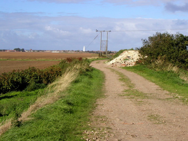
English: The Hull to Withernsea Railway west of Hollym, East Riding of Yorkshire, England. This is the view just SSW of Withernsea on the old track bed. The railway was closed to passengers in about October 1964 after being the victim of Dr. Beeching's cuts. The trackbed is now mainly used for farmland access. Nearer Patrington, parts of it are no more and the land has been transformed once again into farmland. |
| Date | |
| Source | From geograph.org.uk |
| Author | Andy Beecroft |
| Permission (Reusing this file) |
Creative Commons Attribution Share-alike license 2.0 |
| Attribution (required by the license) | Andy Beecroft / The Hull to Withernsea Railway / |
| Camera location | | View this and other nearby images on: OpenStreetMap |
|---|
_heading:22.00&language=en)
| Object location | | View this and other nearby images on: OpenStreetMap |
|---|
_heading:22.00&language=en)
Licensing
[edit]

|
This image was taken from the Geograph project collection. See this photograph's page on the Geograph website for the photographer's contact details. The copyright on this image is owned by Andy Beecroft and is licensed for reuse under the Creative Commons Attribution-ShareAlike 2.0 license.
|
This file is licensed under the Creative Commons Attribution-Share Alike 2.0 Generic license.
Attribution: Andy Beecroft
- You are free:
- to share – to copy, distribute and transmit the work
- to remix – to adapt the work
- Under the following conditions:
- attribution – You must give appropriate credit, provide a link to the license, and indicate if changes were made. You may do so in any reasonable manner, but not in any way that suggests the licensor endorses you or your use.
- share alike – If you remix, transform, or build upon the material, you must distribute your contributions under the same or compatible license as the original.
File history
Click on a date/time to view the file as it appeared at that time.
| Date/Time | Thumbnail | Dimensions | User | Comment | |
|---|---|---|---|---|---|
| current | 02:28, 1 February 2010 | | 640 × 480 (95 KB) | GeographBot (talk | contribs) | == {{int:filedesc}} == {{Information |description={{en|1=The Hull to Withernsea Railway. This is the view just SSW of Withernsea on the old track bed. The railway was closed to passengers in about October 1964 after being the victim of Dr. Beeching's cut |
You cannot overwrite this file.
File usage on Commons
The following page uses this file:
File usage on other wikis
The following other wikis use this file:
- Usage on en.wikipedia.org
- Usage on www.wikidata.org