File:The Gries village church from 1852 at a heigth of 1569 m in the Februari 2012 morningsun - panoramio.jpg
Jump to navigation
Jump to search

Size of this preview: 800 × 530 pixels. Other resolutions: 320 × 212 pixels | 640 × 424 pixels | 1,024 × 678 pixels | 1,280 × 848 pixels | 2,560 × 1,696 pixels | 4,928 × 3,264 pixels.
Original file (4,928 × 3,264 pixels, file size: 4.36 MB, MIME type: image/jpeg)
Captions
Captions
Add a one-line explanation of what this file represents
Summary
[edit]
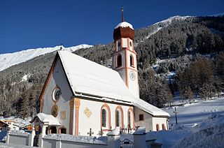
| Description | The Gries village church from 1852 at a heigth of 1569 m in the February 2012 morningsun. | ||
| Date | Taken on 21 February 2012 | ||
| Source | https://web.archive.org/web/20161021171620/http://www.panoramio.com/photo/67948061 | ||
| Author | Henk Monster | ||
| Permission (Reusing this file) |
This file is licensed under the Creative Commons Attribution 3.0 Unported license. Attribution: Henk Monster
|
||
| Tags (from Panoramio photo page) | Gemeinde Längenfeld, buildings, kerktoren or church tower, tirol |
| Camera location | | View this and other nearby images on: OpenStreetMap |
|---|
File history
Click on a date/time to view the file as it appeared at that time.
| Date/Time | Thumbnail | Dimensions | User | Comment | |
|---|---|---|---|---|---|
| current | 01:16, 29 December 2016 | | 4,928 × 3,264 (4.36 MB) | Panoramio upload bot (talk | contribs) | == {{int:filedesc}} == {{Information |description=The Gries village church from 1852 at a heigth of 1569 m in the Februari 2012 morningsun |date={{Taken on|2012-02-21}} |source=http://www.panoramio.com/photo/67948061 |author=[http://www.panoramio.com/u... |
You cannot overwrite this file.
File usage on Commons
The following 2 pages use this file: