File:The Grand Sable Dunes west of Grand Marais are one of the major features of the park and are among the best examples of perched (ab741074-ef4f-43c4-8e42-c701ba38832c).JPG
Jump to navigation
Jump to search

Size of this preview: 800 × 600 pixels. Other resolutions: 320 × 240 pixels | 640 × 480 pixels | 1,024 × 768 pixels | 1,280 × 960 pixels | 2,560 × 1,920 pixels | 4,032 × 3,024 pixels.
Original file (4,032 × 3,024 pixels, file size: 2.22 MB, MIME type: image/jpeg)
Captions
Captions
Add a one-line explanation of what this file represents

|
The categories of this image need checking. You can do so here.
|
.JPG&action=edit&withJS=MediaWiki:Catcheck.js)
Summary
[edit].JPG&action=edit§ion=1)
| English: Grand Sable Dunes | ||||
|---|---|---|---|---|
| Photographer |
English: NPS |
|||
| Title |
English: Grand Sable Dunes |
|||
| Description |
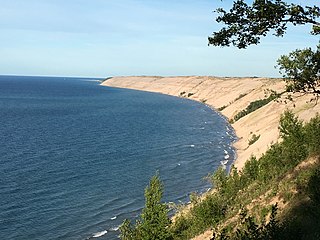
English: Grand Sable Dunes rising 300 feet above Lake Superior The Grand Sable Dunes west of Grand Marais are one of the major features of the park and are among the best examples of perched dune systems in the world. Rising more than 300 feet above the lake, the Grand Sable Dunes are the highest formation in the park. They comprise five square miles and contain uncommon plant species and communities, including the richest orchid flora in the Great Lakes and the federally endangered Pitcher's Thistle.
|
|||
| Depicted place |
English: Pictured Rocks National Lakeshore, Alger County, Michigan |
|||
| Date | Taken on 15 July 2016 | |||
| Accession number | ||||
| Source |
English: NPGallery |
|||
| Permission (Reusing this file) |
|
|||
| NPS Unit Code | PIRO | |||
File history
Click on a date/time to view the file as it appeared at that time.
| Date/Time | Thumbnail | Dimensions | User | Comment | |
|---|---|---|---|---|---|
| current | 22:08, 15 January 2022 | | 4,032 × 3,024 (2.22 MB) | BMacZeroBot (talk | contribs) | Batch upload (Commons:Batch uploading/NPGallery) |
You cannot overwrite this file.
File usage on Commons
The following page uses this file:
.JPG)
.JPG&oldid=622009104)