File:The Euphrates Valley - Syria, Kurdistan, etc. LOC 2013593032 - detail Ahwaz - Shustar - Karun Jarahi Zohreh rivers (cropped).jpg
Jump to navigation
Jump to search

Size of this preview: 519 × 600 pixels. Other resolutions: 208 × 240 pixels | 415 × 480 pixels | 664 × 768 pixels | 886 × 1,024 pixels | 1,449 × 1,675 pixels.
Original file (1,449 × 1,675 pixels, file size: 430 KB, MIME type: image/jpeg)
Captions
Captions
Add a one-line explanation of what this file represents
Summary
[edit]| Description |
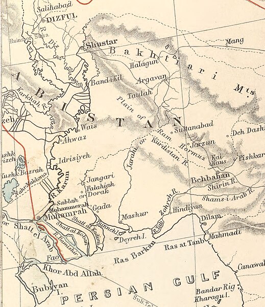
English: Persian Gulf, Shatt el Arab, detail with towns Ahwaz, Shushtar, Behbahan, Hindiyan (Hendijan) rivers Karun, Jarahi, Zohreh, Shatt al Koban, Shatt al Kadimi, Deyreh (Dara) Island. Text from original (greater) map: Shows railroads and submarine telegraph cables. Shows Turkish territory colored in green, and the Vilayets (states) separated by red lines. Relief shown by hachures. Publication list of Stanford's leading atlases on verso. "1514." Available also through the Library of Congress Web site as a raster image. |
||
| Title | The Euphrates Valley : Syria, Kurdistan, &c. | ||
| Shelf ID | G7420 19-- .E3 | ||
| Date | |||
| Source | https://www.loc.gov/item/2013593032/ | ||
| Author |
Edward Stanford Ltd crop of map: Ludwig Sebastian Micheler |
||
| Permission (Reusing this file) |
|
||
| Other versions |
|
||
| Location | Middle East | ||
| Part of | American Memory · General Maps · Catalog · Geography And Map Division | ||
| Subject | Maps · Middle East |


.jpg&action=edit§ion=1)
Licensing
[edit].jpg&action=edit§ion=2)
|
This is a faithful photographic reproduction of a two-dimensional, public domain work of art. The work of art itself is in the public domain for the following reason:
The official position taken by the Wikimedia Foundation is that "faithful reproductions of two-dimensional public domain works of art are public domain".
This photographic reproduction is therefore also considered to be in the public domain in the United States. In other jurisdictions, re-use of this content may be restricted; see Reuse of PD-Art photographs for details. | ||||
| Annotations | This image is annotated: View the annotations at Commons |
.jpg)
File history
Click on a date/time to view the file as it appeared at that time.
| Date/Time | Thumbnail | Dimensions | User | Comment | |
|---|---|---|---|---|---|
| current | 21:25, 13 June 2024 | | 1,449 × 1,675 (430 KB) | LudwigSebastianMicheler (talk | contribs) | File:The Euphrates Valley - Syria, Kurdistan, etc. LOC 2013593032.jpg cropped 83 % horizontally, 69 % vertically, 95 % areawise using CropTool with lossless mode. |
You cannot overwrite this file.
File usage on Commons
The following 4 pages use this file:
File usage on other wikis
The following other wikis use this file:
- Usage on de.wikipedia.org
.jpg&oldid=884571699)