File:The Edinburgh Dome - geograph.org.uk - 303213.jpg
The_Edinburgh_Dome_-_geograph.org.uk_-_303213.jpg (640 × 435 pixels, file size: 236 KB, MIME type: image/jpeg)
Captions
Captions
Summary
[edit]
| Description |
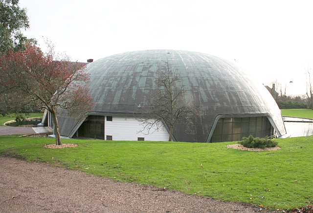
English: The Edinburgh Dome, Imperial Road, Malvern, Worcestershire. The building belongs to Malvern St James School and was built as a sports hall. It was named after the Duke of Edinburgh who opened it in 1978. The sports hall has now moved to a new one on Barnards Green Road. In 2006 the school applied for planning permission to demolish the dome but was turned down. In 2009 the Department of Culture, Media and Sport made the dome a Grade II listed building.
The dome is a concrete parashell and is the only one in the country. It was built by a pioneering technique in which liquid cement was poured onto a special neoprene membrane and then pneumatically inflated; in this case to a height of 11 metres. It took just an hour to complete the inflation and two weeks to complete the building. A moat was built around the base and openings made for doors, windows and for light to reflect off the surrounding water to light the inside of the dome. The parashell was invented by an Italian, Dante Bini, in 1967. The architects here were Godwin and Cowper of Stourport. The construction technique appeared simple, but in fact required a great deal of meticulous planning and seemingly a good deal of luck, which perhaps explains why this structure is still unique in the UK! |
| Date | |
| Source | From geograph.org.uk |
| Author | Bob Embleton |
| Attribution (required by the license) | Bob Embleton / The Edinburgh Dome / |
| Camera location | | View this and other nearby images on: OpenStreetMap |
|---|
_heading:135.00&language=en)
| Object location | | View this and other nearby images on: OpenStreetMap |
|---|
_heading:135.00&language=en)
Licensing
[edit]

|
This image was taken from the Geograph project collection. See this photograph's page on the Geograph website for the photographer's contact details. The copyright on this image is owned by Bob Embleton and is licensed for reuse under the Creative Commons Attribution-ShareAlike 2.0 license.
|
- You are free:
- to share – to copy, distribute and transmit the work
- to remix – to adapt the work
- Under the following conditions:
- attribution – You must give appropriate credit, provide a link to the license, and indicate if changes were made. You may do so in any reasonable manner, but not in any way that suggests the licensor endorses you or your use.
- share alike – If you remix, transform, or build upon the material, you must distribute your contributions under the same or compatible license as the original.
File history
Click on a date/time to view the file as it appeared at that time.
| Date/Time | Thumbnail | Dimensions | User | Comment | |
|---|---|---|---|---|---|
| current | 22:42, 22 December 2010 | | 640 × 435 (236 KB) | GeographBot (talk | contribs) | == {{int:filedesc}} == {{Information |description={{en|1=The Edinburgh Dome The Edinburgh Dome, off Imperial Road, is owned by Malvern St James School and was built as a sports hall. It was named after the Duke of Edinburgh who opened it in 1978. The spor |
You cannot overwrite this file.
File usage on Commons
The following page uses this file:
File usage on other wikis
The following other wikis use this file:
- Usage on arz.wikipedia.org
- Usage on fr.wikipedia.org
- Usage on nl.wikipedia.org