File:The East Suffolk line runs here no more - geograph.org.uk - 1483050.jpg
Jump to navigation
Jump to search
No higher resolution available.
The_East_Suffolk_line_runs_here_no_more_-_geograph.org.uk_-_1483050.jpg (640 × 464 pixels, file size: 111 KB, MIME type: image/jpeg)
Captions
Captions
Add a one-line explanation of what this file represents
Summary
[edit]
| Description |
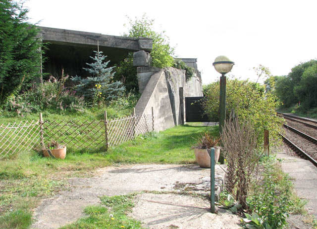
English: The East Suffolk line runs here no more This view was taken from the southbound platform of Haddiscoe station which is presently served by The Wherry Line Railways, linking the city of Norwich with Great Yarmouth and Lowestoft, traversing the eastern section of the Norfolk Broads and running along the rivers Wensum, Waveney and Yare. The name of the Wherry Lines railway routes recognises the important role once played by the Norfolk Wherries, which prior to road and rail developments, were the main transport around the broads and rivers in this area of Norfolk. http://www.wherrylines.org.uk/
The abutments of a dismantled railway bridge seen here form the boundary of a garden which once used to be the location of Haddiscoe high level station. The former railway bridge used to carry the East Suffolk line (Beccles to Yarmouth Southtown mainline) into Haddiscoe high level station - so called because of its close proximity to Haddiscoe railway station which is presently served by the Wherry Line (at right). The two stations used to be linked - the link being controlled by the Haddiscoe Junction signal box. |
| Date | |
| Source | From geograph.org.uk |
| Author | Evelyn Simak |
| Attribution (required by the license) | Evelyn Simak / The East Suffolk line runs here no more / |
| Camera location | | View this and other nearby images on: OpenStreetMap |
|---|
_heading:135.00&language=en)
| Object location | | View this and other nearby images on: OpenStreetMap |
|---|
_heading:135.00&language=en)
Licensing
[edit]

|
This image was taken from the Geograph project collection. See this photograph's page on the Geograph website for the photographer's contact details. The copyright on this image is owned by Evelyn Simak and is licensed for reuse under the Creative Commons Attribution-ShareAlike 2.0 license.
|
This file is licensed under the Creative Commons Attribution-Share Alike 2.0 Generic license.
Attribution: Evelyn Simak
- You are free:
- to share – to copy, distribute and transmit the work
- to remix – to adapt the work
- Under the following conditions:
- attribution – You must give appropriate credit, provide a link to the license, and indicate if changes were made. You may do so in any reasonable manner, but not in any way that suggests the licensor endorses you or your use.
- share alike – If you remix, transform, or build upon the material, you must distribute your contributions under the same or compatible license as the original.
File history
Click on a date/time to view the file as it appeared at that time.
| Date/Time | Thumbnail | Dimensions | User | Comment | |
|---|---|---|---|---|---|
| current | 15:30, 2 March 2011 | | 640 × 464 (111 KB) | GeographBot (talk | contribs) | == {{int:filedesc}} == {{Information |description={{en|1=The East Suffolk line runs here no more This view was taken from the southbound platform of Haddiscoe station which is presently served by The Wherry Line Railways, linking the city of Norwich with |
You cannot overwrite this file.
File usage on Commons
There are no pages that use this file.