File:The Crew Module, part the Crew Escape System (CES), floating back to earth under its parachutes over the Bay of Bengal about 2.9 km from the Satish Dhawan Space Centre, Sriharikota.JPG
Jump to navigation
Jump to search

Size of this preview: 638 × 599 pixels. Other resolutions: 255 × 240 pixels | 511 × 480 pixels | 817 × 768 pixels | 1,090 × 1,024 pixels | 1,788 × 1,680 pixels.
Original file (1,788 × 1,680 pixels, file size: 468 KB, MIME type: image/jpeg)
Captions
Captions
Add a one-line explanation of what this file represents
Summary
[edit]| Description |
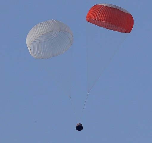
English: The Crew Module, part the Crew Escape System (CES), floating back to earth under its parachutes over the Bay of Bengal about 2.9 km from the Satish Dhawan Space Centre, Sriharikota, during a test conducted by the Indian Space Research Organisation (ISRO), in Andhra Pradesh on July 05, 2018. |
||||||||||||||||||||||
| Date | |||||||||||||||||||||||
| Source |
|
||||||||||||||||||||||
| Author |
|
||||||||||||||||||||||

,_floating_back_to_earth_under_its_parachutes_over_the_Bay_of_Bengal_about_2.9_km_from_the_Satish_Dhawan_Space_Centre,_Sriharikota.JPG&action=edit§ion=1)
| Camera location | | View this and other nearby images on: OpenStreetMap |
|---|
,_floating_back_to_earth_under_its_parachutes_over_the_Bay_of_Bengal_about_2.9_km_from_the_Satish_Dhawan_Space_Centre,_Sriharikota.JPG¶ms=013.733257_N_0080.234903_E_globe:Earth_type:camera_alt:68.5_source:exif_&language=en)
Licensing
[edit],_floating_back_to_earth_under_its_parachutes_over_the_Bay_of_Bengal_about_2.9_km_from_the_Satish_Dhawan_Space_Centre,_Sriharikota.JPG&action=edit§ion=2)

|
This file is a copyrighted work of the Government of India, licensed under the Government Open Data License - India (GODL).
Information on Related Items:
|
 |
| Attribution: Department of Space (GODL-India) | ||
|
|
This image, which was originally posted in http://pib.nic.in/newsite/photo.aspx?photoid=128155, was reviewed on 2018-09-10 by the administrator or reviewer GazothBot, who confirmed that it was available on that source on that date.
|
File history
Click on a date/time to view the file as it appeared at that time.
| Date/Time | Thumbnail | Dimensions | User | Comment | |
|---|---|---|---|---|---|
| current | 04:45, 10 September 2018 | | 1,788 × 1,680 (468 KB) | GazothBot (talk | contribs) | Uploading Press Information Bureau image with ID 128155 |
You cannot overwrite this file.
File usage on Commons
The following page uses this file:
File usage on other wikis
The following other wikis use this file:
- Usage on en.wikipedia.org
- Usage on zh.wikipedia.org
,_floating_back_to_earth_under_its_parachutes_over_the_Bay_of_Bengal_about_2.9_km_from_the_Satish_Dhawan_Space_Centre,_Sriharikota.JPG&oldid=813851881)