File:The Connor Pass - geograph.org.uk - 1415294.jpg
Jump to navigation
Jump to search
No higher resolution available.
The_Connor_Pass_-_geograph.org.uk_-_1415294.jpg (640 × 427 pixels, file size: 84 KB, MIME type: image/jpeg)
Captions
Captions
Add a one-line explanation of what this file represents
Summary
[edit]
| Description |
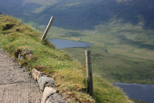
English: The Connor Pass This is the edge of the R560 road at the summit of the Connor Pass. The Conor Pass is reputedly the highest road in Ireland at around 410m. It may look hairy with a drop here of some 300m but there is a TIMBER crash barrier on the left just out of image. An Loch Geal and Loch Ui Fhiannachta can be seen, with the Brandon Mountains rising behind. |
| Date | |
| Source | From geograph.org.uk |
| Author | Adrian Platt |
| Attribution (required by the license) | Adrian Platt / The Connor Pass / |
| Camera location | | View this and other nearby images on: OpenStreetMap |
|---|
_heading:0.00&language=en)
| Object location | | View this and other nearby images on: OpenStreetMap |
|---|
_heading:0.00&language=en)
Licensing
[edit]

|
This image was taken from the Geograph project collection. See this photograph's page on the Geograph website for the photographer's contact details. The copyright on this image is owned by Adrian Platt and is licensed for reuse under the Creative Commons Attribution-ShareAlike 2.0 license.
|
This file is licensed under the Creative Commons Attribution-Share Alike 2.0 Generic license.
Attribution: Adrian Platt
- You are free:
- to share – to copy, distribute and transmit the work
- to remix – to adapt the work
- Under the following conditions:
- attribution – You must give appropriate credit, provide a link to the license, and indicate if changes were made. You may do so in any reasonable manner, but not in any way that suggests the licensor endorses you or your use.
- share alike – If you remix, transform, or build upon the material, you must distribute your contributions under the same or compatible license as the original.
File history
Click on a date/time to view the file as it appeared at that time.
| Date/Time | Thumbnail | Dimensions | User | Comment | |
|---|---|---|---|---|---|
| current | 17:12, 1 March 2011 | | 640 × 427 (84 KB) | GeographBot (talk | contribs) | == {{int:filedesc}} == {{Information |description={{en|1=The Connor Pass This is the edge of the R560 road at the summit of the Connor Pass. The Conor Pass is reputedly the highest road in Ireland at around 410m. It may look hairy with a drop here of some |
You cannot overwrite this file.
File usage on Commons
There are no pages that use this file.