File:The Clarence, Great Scotland Yard - geograph.org.uk - 636217.jpg
Jump to navigation
Jump to search
Size of this preview: 399 × 599 pixels. Other resolutions: 160 × 240 pixels | 426 × 640 pixels.
Original file (426 × 640 pixels, file size: 98 KB, MIME type: image/jpeg)
Captions
Captions
Add a one-line explanation of what this file represents
Summary
[edit]
| Description |
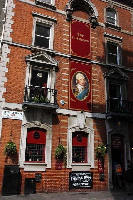
English: "The Clarence" pub, standing on the corner of Great Scotland Yard and Whitehall. The pub dates from 1896 and at that time was attached to the opposite corner across Great Scotland Yard by an archway. In 1908 the archway was removed in the redevelopment of Great Scotland Yard, the end of the building was refaced with newer and slightly different coloured bricks as can be seen in the photograph. |
| Date | |
| Source | From geograph.org.uk |
| Author | Philip Halling |
| Other versions |
  |
| Attribution (required by the license) | Philip Halling / The Clarence, Great Scotland Yard / |
| Camera location | | View this and other nearby images on: OpenStreetMap |
|---|
_heading:0.00&language=en)
| Object location | | View this and other nearby images on: OpenStreetMap |
|---|
_heading:0.00&language=en)
Licensing
[edit]

|
This image was taken from the Geograph project collection. See this photograph's page on the Geograph website for the photographer's contact details. The copyright on this image is owned by Philip Halling and is licensed for reuse under the Creative Commons Attribution-ShareAlike 2.0 license.
|
This file is licensed under the Creative Commons Attribution-Share Alike 2.0 Generic license.
Attribution: Philip Halling
- You are free:
- to share – to copy, distribute and transmit the work
- to remix – to adapt the work
- Under the following conditions:
- attribution – You must give appropriate credit, provide a link to the license, and indicate if changes were made. You may do so in any reasonable manner, but not in any way that suggests the licensor endorses you or your use.
- share alike – If you remix, transform, or build upon the material, you must distribute your contributions under the same or compatible license as the original.
File history
Click on a date/time to view the file as it appeared at that time.
| Date/Time | Thumbnail | Dimensions | User | Comment | |
|---|---|---|---|---|---|
| current | 10:35, 7 February 2011 | | 426 × 640 (98 KB) | GeographBot (talk | contribs) | == {{int:filedesc}} == {{Information |description={{en|1=The Clarence, Great Scotland Yard The Clarence standing on the corner of Great Scotland Yard and Whitehall.}} |date=2007-04-09 |source=From [http://www.geograph.org.uk/photo/636217 geograph.org.uk] |
You cannot overwrite this file.
File usage on Commons
The following page uses this file: