File:The Celia Fiennes Waymark - geograph.org.uk - 283773.jpg
From Wikimedia Commons, the free media repository
Jump to navigation
Jump to search
The_Celia_Fiennes_Waymark_-_geograph.org.uk_-_283773.jpg (640 × 480 pixels, file size: 135 KB, MIME type: image/jpeg)
File information
Structured data
Captions
Captions
Add a one-line explanation of what this file represents
Summary
[edit]| DescriptionThe Celia Fiennes Waymark - geograph.org.uk - 283773.jpg |
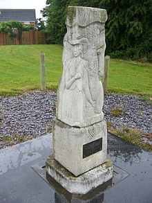
English: The Celia Fiennes Waymark, No Man's Heath, Cheshire. The waymark which has become known locally as "The Monument", was unveiled on a very cold, wet and windy day in December 1998. It was commissioned to commemorate the 300th anniversary of the "Great Journey" undertaken by a remarkable lady who, in the reign of William and Mary, travelled throughout Great Britain, riding side saddle and with only the minimum of company. Part of her route in 1698 brought her down the Old Coach Road to join the medieval road from Chester, which later became the A41, on her way to stay the night in Whitchurch. During all of her travellings, this was the only time in which she encountered highwaymen! Two rather shady characters followed her down the road from Tarporley, through Beeston, Bulkeley and Hampton Post and then into No Mans Heath itself. Fortunately it was market day in Whitchurch and, as Celia approached the town, the highwaymen backed off, deterred by the increasing crowd of market-goers. Look closely at the monument and you will see carvings of Celia herself, her horse, the highwaymen and the market people. |
| Date | |
| Source | From this image at geograph.org.uk; transferred by User:RHaworth using geograph_org2commons. |
| Author | Graham Flint |
| Permission (Reusing this file) |
Creative Commons Attribution Share-alike license 2.0 |
| Other versions |
 |
| Camera location | 53° 01′ 24.6″ N, 2° 43′ 17.53″ W | View this and other nearby images on: OpenStreetMap |
|---|
| Object location | 53° 01′ 29″ N, 2° 43′ 19″ W | View this and other nearby images on: OpenStreetMap |
|---|
Licensing
[edit]
|
This image was taken from the Geograph project collection. See this photograph's page on the Geograph website for the photographer's contact details. The copyright on this image is owned by Graham Flint and is licensed for reuse under the Creative Commons Attribution-ShareAlike 2.0 license.
|
This file is licensed under the Creative Commons Attribution-Share Alike 2.0 Generic license.
Attribution: Graham Flint
- You are free:
- to share – to copy, distribute and transmit the work
- to remix – to adapt the work
- Under the following conditions:
- attribution – You must give appropriate credit, provide a link to the license, and indicate if changes were made. You may do so in any reasonable manner, but not in any way that suggests the licensor endorses you or your use.
- share alike – If you remix, transform, or build upon the material, you must distribute your contributions under the same or compatible license as the original.
File history
Click on a date/time to view the file as it appeared at that time.
| Date/Time | Thumbnail | Dimensions | User | Comment | |
|---|---|---|---|---|---|
| current | 01:30, 30 March 2010 |  | 640 × 480 (135 KB) | File Upload Bot (Magnus Manske) (talk | contribs) | == {{int:filedesc}} == {{Information |Description={{en|1=The Celia Fiennes Waymark}} |Source=From [http://www.geograph.org.uk/photo/283773 this image] at [http://geograph.org.uk geograph.org.uk]; transferred by User:RHaworth using [http://toolserver.o |
You cannot overwrite this file.
File usage on Commons
The following page uses this file:
Metadata
This file contains additional information such as Exif metadata which may have been added by the digital camera, scanner, or software program used to create or digitize it. If the file has been modified from its original state, some details such as the timestamp may not fully reflect those of the original file. The timestamp is only as accurate as the clock in the camera, and it may be completely wrong.
| Image title | DCF 1.0 |
|---|---|
| Camera manufacturer | Minolta Co., Ltd. |
| Camera model | DiMAGE 5 |
| ISO speed rating | 100 |
| Date and time of data generation | 10:18, 6 May 2006 |
| Lens focal length | 11.625 mm |
| Orientation | Normal |
| Horizontal resolution | 72 dpi |
| Vertical resolution | 72 dpi |
| Software used | A2v056e |
| File change date and time | 10:18, 6 May 2006 |
| Y and C positioning | Centered |
| Exposure Program | Normal program |
| Exif version | 2.1 |
| Date and time of digitizing | 10:18, 6 May 2006 |
| APEX shutter speed | 8.5 |
| APEX aperture | 5 |
| APEX exposure bias | 0 |
| Maximum land aperture | 3.5 APEX (f/3.36) |
| Metering mode | Pattern |
| Light source | Unknown |
| Flash | Flash did not fire |
| Color space | sRGB |
