File:The Blackbrook Basin Terminus of the Sankey Canal - geograph.org.uk - 334643.jpg
Jump to navigation
Jump to search
No higher resolution available.
The_Blackbrook_Basin_Terminus_of_the_Sankey_Canal_-_geograph.org.uk_-_334643.jpg (640 × 426 pixels, file size: 91 KB, MIME type: image/jpeg)
Captions
Captions
Add a one-line explanation of what this file represents
Summary
[edit]
| Description |
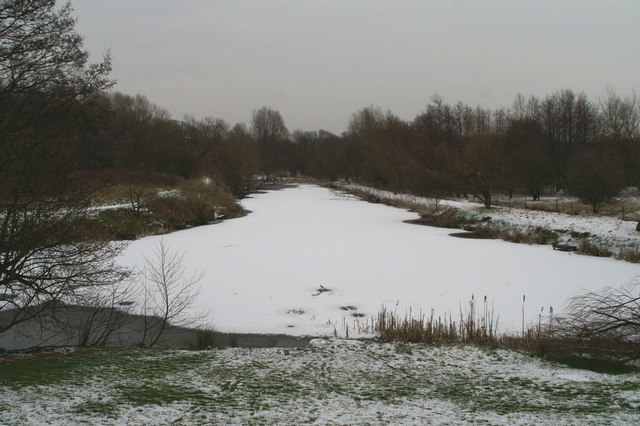
English: The Blackbrook Basin Terminus of the Sankey Canal The Sankey Brook Navigation, commonly known as the Sankey Canal, was built between 1755 and 1757, making this the 250th Anniversary year of its opening.
The northern reaches of the canal were formally abandoned in 1931. This site, now the start of the Sankey Valley Linear Park, following the line of the canal to Widnes, would have been a hive of activity in the 18th & 19th Centuries. Coal was loaded here into Mersey flats to go to Liverpool, North Wales, Ireland, and the Lancashire coast, while copper ore was imported from Parys Mountain on Anglesey to a copper works nearby. |
| Date | |
| Source | From geograph.org.uk |
| Author | David Long |
| Attribution (required by the license) | David Long / The Blackbrook Basin Terminus of the Sankey Canal / |
| Camera location | | View this and other nearby images on: OpenStreetMap |
|---|
_heading:157.00&language=en)
| Object location | | View this and other nearby images on: OpenStreetMap |
|---|
_heading:157.00&language=en)
Licensing
[edit]

|
This image was taken from the Geograph project collection. See this photograph's page on the Geograph website for the photographer's contact details. The copyright on this image is owned by David Long and is licensed for reuse under the Creative Commons Attribution-ShareAlike 2.0 license.
|
This file is licensed under the Creative Commons Attribution-Share Alike 2.0 Generic license.
Attribution: David Long
- You are free:
- to share – to copy, distribute and transmit the work
- to remix – to adapt the work
- Under the following conditions:
- attribution – You must give appropriate credit, provide a link to the license, and indicate if changes were made. You may do so in any reasonable manner, but not in any way that suggests the licensor endorses you or your use.
- share alike – If you remix, transform, or build upon the material, you must distribute your contributions under the same or compatible license as the original.
File history
Click on a date/time to view the file as it appeared at that time.
| Date/Time | Thumbnail | Dimensions | User | Comment | |
|---|---|---|---|---|---|
| current | 22:39, 30 December 2010 | | 640 × 426 (91 KB) | GeographBot (talk | contribs) | == {{int:filedesc}} == {{Information |description={{en|1=The Blackbrook Basin Terminus of the Sankey Canal The Sankey Brook Navigation, commonly known as the Sankey Canal, was built between 1755 and 1757, making this the 250th Anniversary year of its open |
You cannot overwrite this file.
File usage on Commons
There are no pages that use this file.