File:The Arid Heart of Central Asia (MODIS 2020-09-30).jpg

Original file (4,539 × 3,351 pixels, file size: 1.05 MB, MIME type: image/jpeg)
Captions
Captions
Summary
[edit].jpg&action=edit§ion=1)
| Description |
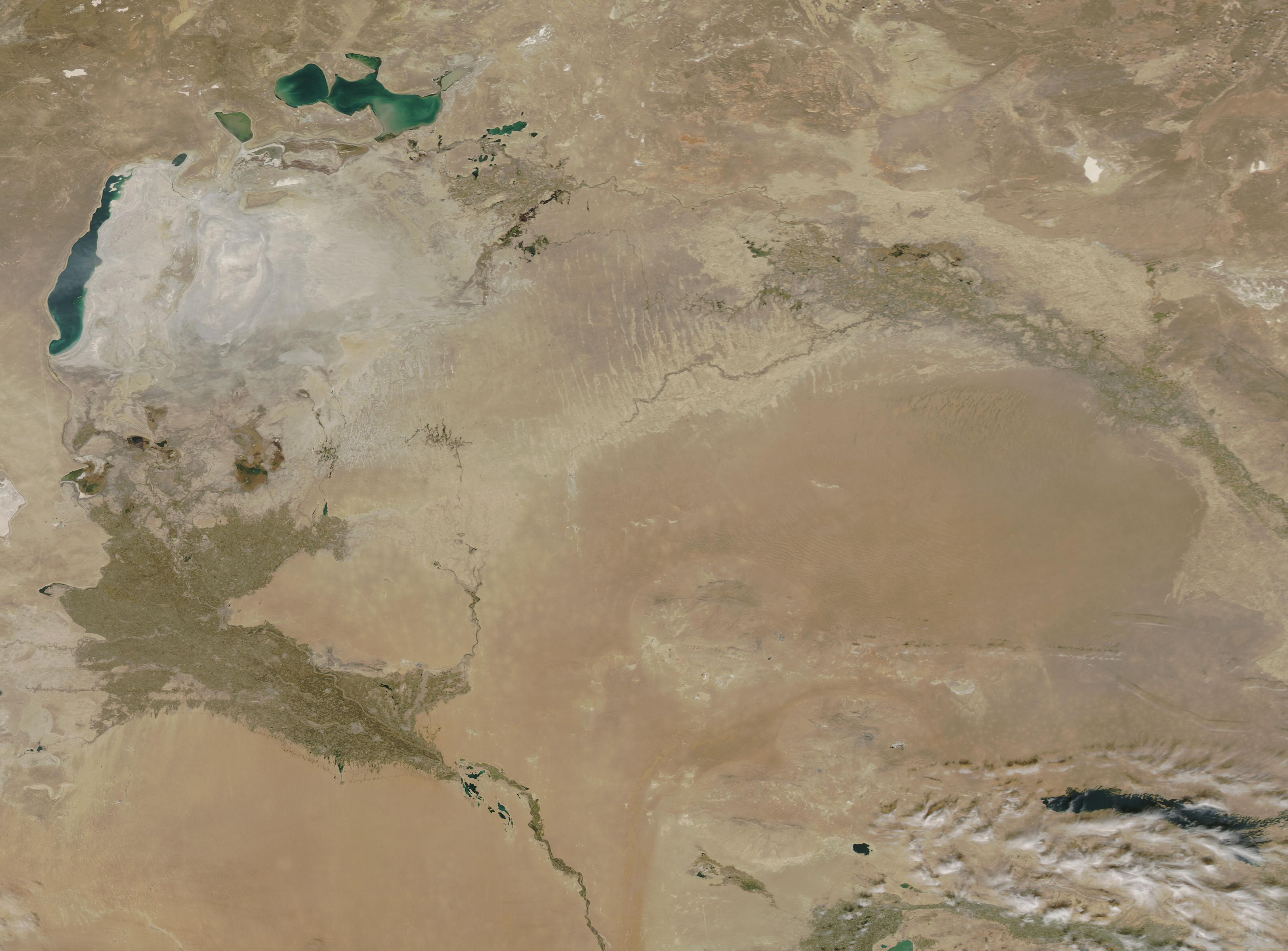
English: On September 27, 2020, NASA’s Aqua satellite passed over Central Asia, allowing the Moderate Resolution Imaging Spectroradiometer (MODIS) on board to acquire a true-color image of the arid landscape of the region.
Parts of three countries are visible in this image: Kazakhstan (north), Uzbekistan (center), and Turkmenistan (south). While much of the landscape of all three countries has always been arid in recent history, this area was a notable exception, thanks to the flowing waters of two major rivers, the Amu Darya and the Syr Darya, which fed vegetation along the riversides and filled the Aral Sea, making it the fourth-largest lake on Earth and a vibrant, fish-filled lake supporting a flourishing economy. A contemporary description was penned by the Polish Writer Ryszard Kapuściński as he traveled in this region in the 1950s. He states, “Central Asia is deserts and more deserts, fields of brown weathered stones, the heat from the sun above, sandstorms. But the world of the Syr Darya and the Amu Darya is different. Arable fields stretch along both rivers, abundant orchards; everywhere profusions of nut trees, apple trees, fig trees, palms, pomegranates…This way, too, passed the loaded-down caravans of the Silk Road, thanks to which the markets of Venice and Florence, Nice and Seville, acquired their importance and color”. In the 1950s and 1960s the government of the Soviet Union wanted to exchange small farms for cotton and other more marketable or profitable crops. The two major rivers, both the Syr Darya and the Amu Darya, were diverted to the expanding agriculture. Dams, canals and other water works were built. Although this diversion did make parts of the surrounding desert bloom, the loss of the rivers' inflow soon dried up the Aral Sea, leaving only a small remnant of water and a crust of minerals and pesticide-rich dust. Today's much-reduced Aral Sea sits in the northwest section of the image and appears as a cluster of virtually disconnected small lakes. To the southeast the “shadow” of the original Aral Sea is crusted in white mineral. At the edge of this shadow sits the Aralkum Desert, a new desert created by the loss of the Aral Sea. Rich in pesticides, the fine dust is easily blown by the wind and has been reported to travel to Russia, Norway, and even Antarctica. In the southeast, a rope of green marks the Amu Darya as it winds towards the Aral Sea, and the broad expanse of green marks where the waters spill, unable to reach the lake. The remnants of the Syr Darya can be seen twisting in the northeast, running along the edge of the red sands of the Kyzylkum Desert and disappearing into the desert. |
||
| Date | Taken on 27 September 2020 | ||
| Source |
The Arid Heart of Central Asia (direct link)
|
||
| Author | MODIS Land Rapid Response Team, NASA GSFC |
| This media is a product of the Aqua mission Credit and attribution belongs to the mission team, if not already specified in the "author" row |
Licensing
[edit].jpg&action=edit§ion=2)
| This file is in the public domain in the United States because it was solely created by NASA. NASA copyright policy states that "NASA material is not protected by copyright unless noted". (See Template:PD-USGov, NASA copyright policy page or JPL Image Use Policy.) | ||
 |
Warnings:
|
File history
Click on a date/time to view the file as it appeared at that time.
| Date/Time | Thumbnail | Dimensions | User | Comment | |
|---|---|---|---|---|---|
| current | 19:51, 7 February 2024 | | 4,539 × 3,351 (1.05 MB) | OptimusPrimeBot (talk | contribs) | #Spacemedia - Upload of http://modis.gsfc.nasa.gov/gallery/images/image09302020_250m.jpg via Commons:Spacemedia |
You cannot overwrite this file.
File usage on Commons
There are no pages that use this file.
.jpg&oldid=909382699)